Geolocate

Meerut topographic map

Interactive map

Click on the map to display elevation.

About this map

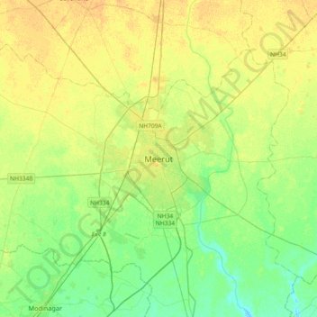
Name: Meerut topographic map, elevation, terrain.

Location: Meerut, Meerut District, Uttar Pradesh, 250003, India (28.82265 77.54810 29.14265 77.86810)

Average elevation: 225 m

Minimum elevation: 214 m

Maximum elevation: 236 m

Other topographic maps

Click on a map to view its topography, its elevation and its terrain.

Kanpur

India > Uttar Pradesh

Situated in the flat Indo-Gangetic Plains, Kanpur has an average elevation of 318 m above sea level. The Ganges flows by the city and several ghats are located on its banks, notably the Sati Chaura Ghat and Sarsaiya Ghat. The Brahmavart Ghat located at Bithoor (25 km northwards) is another ghat of religious…

Average elevation: 124 m

Faridpur

India > Uttar Pradesh

Average elevation: 164 m

Gaur City Stadium

India > Uttar Pradesh > Noida > Dadri

Average elevation: 203 m

Meerut

India > Uttar Pradesh

Average elevation: 223 m

Muzaffarnagar

India > Uttar Pradesh

Average elevation: 241 m