
Thank you for supporting this site ❤️
Make a donation
Make a donation
Meerut topographic map
Click on the map to display elevation.
Thank you for supporting this site ❤️
Make a donation
Make a donation
About this map
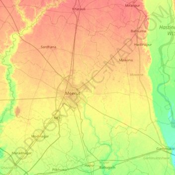
Name: Meerut topographic map, elevation, terrain.
Location: Meerut, Uttar Pradesh, India (28.73691 77.42332 29.26668 78.12487)
Average elevation: 223 m
Minimum elevation: 200 m
Maximum elevation: 246 m
Thank you for supporting this site ❤️
Make a donation
Make a donation
Other topographic maps
Click on a map to view its topography, its elevation and its terrain.
Lucknow
India > Uttar Pradesh > Lucknow
Lucknow stands at an elevation of approximately 123 metres (404 ft) above sea level. The city had an area of 402 km2 (155 square miles) until December 2019, when 88 villages were added to the municipal limits and the area increased to 631 km2 (244 square miles). Bounded on the east by Barabanki, on the west by…
Average elevation: 120 m
Thank you for supporting this site ❤️
Make a donation
Make a donation