
Hokkaido Prefecture topographic map
Interactive map
Click on the map to display elevation.
Hokkaido Prefecture
As Japan's coldest region, Hokkaidō has relatively cool summers and icy/snowy winters. Most of the island falls in the humid continental climate zone with Köppen climate classification Dfb (hemiboreal) in most areas but Dfa (hot summer humid continental) in some inland lowlands. The average August temperature ranges from 17 to 22 °C (62.6 to 71.6 °F), while the average January temperature ranges from −12 to −4 °C (10.4 to 24.8 °F), in both cases depending on elevation and distance from the ocean, though temperatures on the western side of the island tend to be a little warmer than on the eastern. The highest temperature ever recorded is 39.5 °C (103.1 °F) on 26 May 2019.
About this map
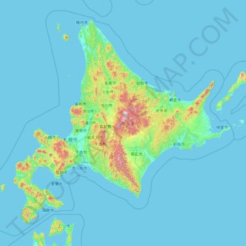
Name: Hokkaido Prefecture topographic map, elevation, terrain.
Location: Hokkaido Prefecture, Japan (41.15206 139.06728 45.71120 145.91603)
Average elevation: 81 m
Minimum elevation: -3 m
Maximum elevation: 2,072 m
Other topographic maps
Click on a map to view its topography, its elevation and its terrain.
Mount Aso
With an elevation of 1,143 metres (3,750 ft)., Mount Aso has a climate that falls as humid continental (Köppen climate classification "Dfb"), with warm summers and cold winters. Precipitation is high throughout the year, which brings the area to have borderline subtropical characteristics as well. It is…
Average elevation: 1,203 m
Mt. Fuji
Japan > Sunto County > Oyama
Mount Fuji (富士山, Fujisan, Japanese: [ɸɯꜜ(d)ʑisaɴ] ) is an active stratovolcano located on the Japanese island of Honshu, with a summit elevation of 3,776.24 m (12,389 ft 3 in). It is the tallest mountain in Japan, the second-highest volcano located on an island in Asia (after Mount Kerinci on the…
Average elevation: 3,261 m
Mt. Omuro
Japan > Minamitsuru County > Doshi
Mount Ōmuro (大室山, Ōmuroyama) is a mountain at an altitude of 1,588 m on the border between Yamanashi and Kanagawa Prefectures in the northern part of the Tanzawa Mountains. It used to be called "Omureyama". It is counted as one of the 100 famous mountains in Yamanashi, and the Kanagawa side is…
Average elevation: 1,116 m
Mount Yōtei
Japan > Abuta County > Kutchan
In the 50,000:1 scale topographical map of the “Rusutsu” area published in 1920 by Japan’s Land Surveying Department, the mountain is recorded as "Shiribeshi-Yōtei-zan (Ezo-Fuji)". However, since the name was difficult to read, the town of Kutchan asked for it to be changed to Yōtei-zan. The change…
Average elevation: 1,395 m