
Make a donation
Taipei topographic map
Click on the map to display elevation.
Make a donation
About this map
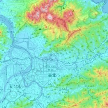
Name: Taipei topographic map, elevation, terrain.
Location: Taipei, Taiwan (24.96052 121.45714 25.21024 121.66594)
Average elevation: 173 m
Minimum elevation: -6 m
Maximum elevation: 1,096 m
Make a donation
Other topographic maps
Click on a map to view its topography, its elevation and its terrain.
Zengwen Dam
Taiwan > Chiayi County > Dapu Township > Maobu
Construction finally began at the Lioutengtan site on October 31, 1967. Two tunnels were excavated through the rock underneath the south abutment of the future dam site. The outer diversion tunnel was 1,240-metre (4,070 ft) long and the inner diversion tunnel was 1,038-metre (3,406 ft). A rolled-earth…
Average elevation: 290 m
Make a donation
Huangguan Island
Taiwan > Fukien Province > Lienchiang County > Huangguan Island
Average elevation: 6 m
Make a donation