
Thank you for supporting this site ❤️
Make a donation
Make a donation
Tamugan topographic map
Click on the map to display elevation.
Thank you for supporting this site ❤️
Make a donation
Make a donation
About this map
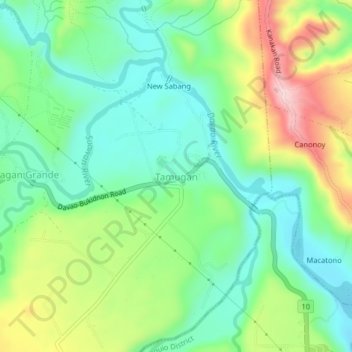
Name: Tamugan topographic map, elevation, terrain.
Location: Tamugan, Davao City, Davao Region, Philippines (7.23114 125.37087 7.27114 125.41087)
Average elevation: 293 m
Minimum elevation: 192 m
Maximum elevation: 488 m
Thank you for supporting this site ❤️
Make a donation
Make a donation
Other topographic maps
Click on a map to view its topography, its elevation and its terrain.
Thank you for supporting this site ❤️
Make a donation
Make a donation
Thank you for supporting this site ❤️
Make a donation
Make a donation
Thank you for supporting this site ❤️
Make a donation
Make a donation
Thank you for supporting this site ❤️
Make a donation
Make a donation
Thank you for supporting this site ❤️
Make a donation
Make a donation