
Make a donation
Queenstown topographic map
Click on the map to display elevation.
Make a donation
Queenstown
The town is at a relatively low altitude for a ski and snowboarding centre, at 310 metres (1,020 ft) above sea level at the lake shore, but is nestled among mountains, most notably the scenic attraction of The Remarkables, to the town's southeast. Below the lake lies the deep Kawarau Gorge, and there are nearby plains suitable for agriculture and viticulture. Queenstown lies close to the heart of the Central Otago wine region.
Make a donation
About this map
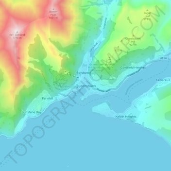
Name: Queenstown topographic map, elevation, terrain.
Average elevation: 592 m
Minimum elevation: 303 m
Maximum elevation: 1,729 m
Queenstown-Lakes District trails, hiking, mountain biking, running and outdoor activities
Make a donation
Other topographic maps
Click on a map to view its topography, its elevation and its terrain.
The Remarkables
New Zealand > Otago > Queenstown-Lakes District
The area contains a number of beautiful features, such as Lake Alta, a small lake nestled within a natural amphitheatre at the head of a glacial valley (a ‘cirque’) and below the towering Double Cone peaks. There are a number of high altitude walks in the Remarkables Conservation Area including Lake Alta…
Average elevation: 1,200 m
Queenstown
New Zealand > Otago > Queenstown-Lakes District
The town is at a relatively low altitude for a ski and snowboarding centre, at 310 metres (1,020 ft) above sea level at the lake shore, but is nestled among mountains, most notably the scenic attraction of The Remarkables, to the town's southeast. Below the lake lies the deep Kawarau Gorge, and there are…
Average elevation: 713 m
Make a donation
Lake Hāwea
New Zealand > Otago > Queenstown-Lakes District
The lake is in the Otago Region at an altitude of 348 metres. It covers 141 km² and reaches 392 metres deep.
Average elevation: 864 m
Lake Wakatipu
New Zealand > Otago > Queenstown-Lakes District
With a length of 80 kilometres (50 mi), it is New Zealand's longest lake, and, at 289 km2 (112 sq mi), its third largest. The lake is also very deep, its floor being below sea level (−110 metres), with a maximum depth of 420 metres (1,380 ft). It is at an altitude of 310 metres (1,020 ft), towards the…
Average elevation: 952 m
Make a donation