
Make a donation
Champawat topographic map
Click on the map to display elevation.
Make a donation
About this map
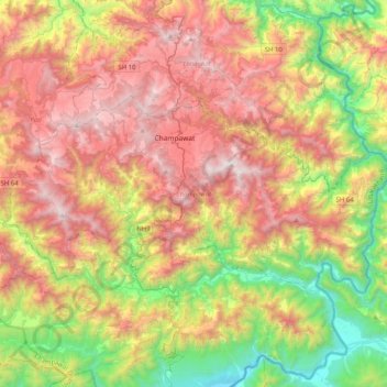
Name: Champawat topographic map, elevation, terrain.
Location: Champawat, Champawat District, Uttarakhand, 262523, India (29.19509 79.91159 29.37612 80.31859)
Average elevation: 1,161 m
Minimum elevation: 260 m
Maximum elevation: 2,174 m
Make a donation
Other topographic maps
Click on a map to view its topography, its elevation and its terrain.
Rudraprayag
India > Uttarakhand > Rudraprayag
Rudraprayag district is located at 30°17′N 78°59′E / 30.28°N 78.98°E / 30.28; 78.98. It has an average elevation of 895 metres (2,936 feet).
Average elevation: 1,140 m
Mussoorie
India > Uttarakhand > Dehradun
Mussoorie is at an average altitude of 2,005 metres (6,578 ft). To the northeast are the Himalayan snow ranges, and to the south, the Doon Valley and Shiwalik ranges. The second highest point is the original Lal Tibba in Landour, with a height of over 2,275 m (7,464 ft). Mussoorie is popularly known as The…
Average elevation: 1,594 m
Dehradun
India > Uttarakhand > Dehradun
The city of Dehradun mainly lies in Doon Valley and is at a varying height from 410 m (1,350 ft) in Clement Town to above 700 m (2,300 ft) at Malsi which is 15 km (9.3 mi) from the city. However, the average elevation is 450 m (1,480 ft) above sea level. Malsi is the starting point of Lesser Himalayan Range…
Average elevation: 904 m
Make a donation