
Shimla topographic map
Click on the map to display elevation.
Shimla
Shimla district is one of the twelve districts of the state of Himachal Pradesh in northern India. Its headquarters is the state capital of Shimla. Neighbouring districts are Mandi and Kullu in the north, Kinnaur in the east, Uttarakhand in the southeast, Solan to the southwest and Sirmaur in the south. The elevation of the district ranges from 987 metres (3,238 ft) to 4,500 metres (14,764 ft).
About this map
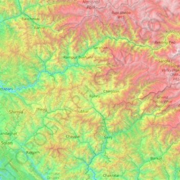
Name: Shimla topographic map, elevation, terrain.
Location: Shimla, Himachal Pradesh, India (30.76403 76.98887 31.71404 78.31711)
Average elevation: 2,526 m
Minimum elevation: 642 m
Maximum elevation: 6,352 m
Other topographic maps
Click on a map to view its topography, its elevation and its terrain.