
Thank you for supporting this site ❤️
Make a donation
Make a donation
Malubog topographic map
Click on the map to display elevation.
Thank you for supporting this site ❤️
Make a donation
Make a donation
About this map
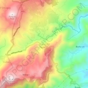
Name: Malubog topographic map, elevation, terrain.
Location: Malubog, Cebu City, Central Visayas, Philippines (10.36039 123.84927 10.40039 123.88927)
Average elevation: 435 m
Minimum elevation: 125 m
Maximum elevation: 719 m
Thank you for supporting this site ❤️
Make a donation
Make a donation
Other topographic maps
Click on a map to view its topography, its elevation and its terrain.