
Make a donation
West Java topographic map
Click on the map to display elevation.
Make a donation
About this map
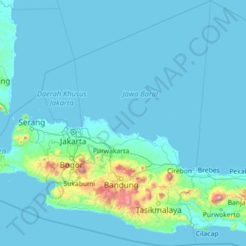
Name: West Java topographic map, elevation, terrain.
Location: West Java, Java, Indonesia (-8.02075 106.05095 -4.03879 109.06979)
Average elevation: 103 m
Minimum elevation: -2 m
Maximum elevation: 3,327 m
Make a donation
Other topographic maps
Click on a map to view its topography, its elevation and its terrain.
Medan
Medan's elevation varies between 2.5 and 37.5 m (8 ft 2 in and 123 ft 0 in) above sea level, with the Barisan Mountains to the south, and volcanoes such as Sibayak Mountain and Sinabung Mountain 50 to 70 km (31 to 43 mi) from the city.
Average elevation: 32 m
Make a donation
Make a donation
Make a donation
Make a donation
Make a donation
Dusun Balekuwu
Indonesia > West Nusa Tenggara > Lombok Barat > Kecamatan Gunungsari
Average elevation: 34 m
Make a donation
Make a donation
Make a donation
Make a donation
Ruang
Indonesia > North Sulawesi > Kepulauan Siau Tagulandang Biaro > Pumpente
Ruang is the southernmost stratovolcano in the Sangihe Islands arc, North Sulawesi, Indonesia. It comprises an island 4 by 5 kilometres (2.5 mi × 3.1 mi) wide. The summit contains a partial lava dome and reaches some 725 metres (2,379 ft) in altitude. From its summit, Klabat's peak in the south, that of Siau…
Average elevation: 274 m
Make a donation
Denpasar
Indonesia > Bali > Dangin Puri
Denpasar is located at an elevation of 4 m (13 ft) above sea level. While the total area of 125.98 km2 or 2.18% of the total area of Bali Province. From the use of land, 2,768 hectares of land are paddy, 10,001 hectares are dry land, while the remaining land area is 9 hectares.
Average elevation: 48 m
Make a donation
Hutan Kota Patriot Bina Bangsa Kota Bekasi
Indonesia > West Java > Bekasi > Kayuringinjaya
Average elevation: 19 m
Make a donation
Make a donation
Embung Tambakboyo
Indonesia > Special Region of Yogyakarta > Sleman Regency > Condongcatur
Average elevation: 164 m
Make a donation
Make a donation
Make a donation
Pulau Bidadari
Indonesia > Special Capital Region of Jakarta > Pulau Untung Jawa
Average elevation: 0 m
Make a donation
Make a donation
Make a donation
Make a donation
Hutan Bambu Andeman Boonpring
Indonesia > East Java > Kabupaten Malang > Wonoayu
Average elevation: 513 m
Make a donation
Sawang Bendar
Indonesia > North Sulawesi > Kepulauan Sangihe > Kelurahan Sawang Bendar
Average elevation: 86 m
Make a donation
Make a donation
Purba
Indonesia > Special Region of Yogyakarta > Gunung Kidul Regency > Nglanggeran
Average elevation: 465 m
Make a donation
Jayapura
The topography of Jayapura varies from valleys to hills, plateaus, and mountains up to 700 metres (2,300 ft) above sea level. Jayapura overlooks the Yos Sudarso Bay. Jayapura is about 94,000 hectares (230,000 acres) in area, and is divided into five districts. Around 30% of the area is inhabited, with the…
Average elevation: 149 m
Make a donation