
Thank you for supporting this site ❤️
Make a donation
Make a donation
Brightwater topographic map
Click on the map to display elevation.
Thank you for supporting this site ❤️
Make a donation
Make a donation
About this map
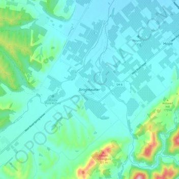
Name: Brightwater topographic map, elevation, terrain.
Location: Brightwater, Tasman, 7022, New Zealand (-41.41488 173.06656 -41.33488 173.14656)
Average elevation: 73 m
Minimum elevation: 13 m
Maximum elevation: 402 m
Tasman trails, hiking, mountain biking, running and outdoor activities
Thank you for supporting this site ❤️
Make a donation
Make a donation
Other topographic maps
Click on a map to view its topography, its elevation and its terrain.