
Make a donation
Zug topographic map
Click on the map to display elevation.
Make a donation
Zug
The canton is located on a hilly plateau. The Höhronen (near Höhboden) is the highest elevation (1,229 m) in the east of the canton. The Zugerberg (1,039 m) in the south is another notable elevation. It connects in the south with the Rossberg massif which rises to the Wildspitz (1,583 m) east of the Zugersee. This massif separates the Zugersee from the basin and Ägerisee. It also separates the hilly district of Menzingen from the Zugersee.
Make a donation
About this map
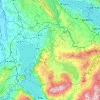
Name: Zug topographic map, elevation, terrain.
Location: Zug, Switzerland (47.08103 8.39484 47.24838 8.70116)
Average elevation: 664 m
Minimum elevation: 384 m
Maximum elevation: 1,560 m
Make a donation
Other topographic maps
Click on a map to view its topography, its elevation and its terrain.
Innerfeld
Switzerland > Bern > Interlaken-Oberhasli administrative district > Saxeten
Average elevation: 1,555 m
Make a donation
Tschierv
Switzerland > Grisons > Region Engiadina Bassa/Val Müstair > Val Müstair
Average elevation: 2,023 m
Kiental
Switzerland > Bern > Frutigen-Niedersimmental administrative district > Reichenbach im Kandertal
Average elevation: 1,363 m
Bern
Switzerland > Bern > Bern-Mittelland administrative district > Bern
Bern is built on very uneven ground. An elevation difference of up to 60 metres exists between the inner city districts on the Aare (Matte, Marzili) and the higher ones (Kirchenfeld, Länggasse).
Average elevation: 643 m
Make a donation
Make a donation