Geolocate

Crow Wing County topographic map

Interactive map

Click on the map to display elevation.

Crow Wing County

Crow Wing County has two state forests, the Crow Wing State Forest and the Emily State Forest. The Cuyuna Lakes State Trail lies in the Upper Mississippi River Basin. The topography is gently rolling to flat, mostly wooded and heavily dotted with waters and wetlands. It is home to an abundance of wildlife, including white-tailed deer, cottontail rabbit, snowshoe hare, raccoon, red fox, gray fox, coyote, mink, muskrat, squirrels, beaver, occasional American black bear, Bald eagle, osprey and many other waterfowl.

Wikipedia (CC-BY-SA 3.0)

About this map

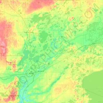
Name: Crow Wing County topographic map, elevation, terrain.

Location: Crow Wing County, Minnesota, United States (46.15592 -94.39572 46.80553 -93.77602)

Average elevation: 386 m

Minimum elevation: 347 m

Maximum elevation: 471 m

Other topographic maps

Click on a map to view its topography, its elevation and its terrain.

Grand Rapids

United States > Minnesota > Itasca County

Average elevation: 398 m

Minnehaha Regional Park

United States > Minnesota > Hennepin County > Minneapolis

Fortunately for the generations to come, in 1883 the state legislature created the Minneapolis Board of Park Commissioners. The board began by acquiring park land near today's downtown Minneapolis. Their choice to hire noted landscape architect Horace Cleveland was fortunate. Cleveland was hired by the Board…

Average elevation: 249 m

Dodge County

United States > Minnesota

Average elevation: 381 m

Minneapolis

United States > Minnesota > Hennepin County

A 1959 report by the US Soil Conservation Service listed Minneapolis's elevation above mean sea level as 830 feet (250 meters). The city's lowest elevation of 687 feet (209 m) above sea level is near the confluence of Minnehaha Creek with the Mississippi River. Sources disagree on the exact location and…

Average elevation: 270 m

Remer

United States > Minnesota > Cass County

According to the United States Census Bureau, the city has an area of 1.38 square miles (3.57 km2), all land. The elevation is 1,342 ft (409 m) above sea level.

Average elevation: 408 m

Rochester

United States > Minnesota > Olmsted County

With a slightly higher altitude and without the UHI as the Twin Cities, the climate is warm-summer humid continental climate (Köppen: Dfb) even being further south, with warm summers and cold winters. The city features four distinct seasons. Rochester sees on average 33.02 inches (839 mm) of rainfall and 51.9…

Average elevation: 354 m

Vesta

United States > Minnesota > Redwood County

Average elevation: 322 m

Otter Tail County

United States > Minnesota

Average elevation: 413 m

Grant County

United States > Minnesota

Average elevation: 347 m

Lonsdale

United States > Minnesota > Rice County

Average elevation: 336 m

Cass Lake

United States > Minnesota > Cass County

Average elevation: 402 m

Duluth

United States > Minnesota > Saint Louis County

Duluth's topography is dominated by a steep hillside that climbs from Lake Superior to high inland elevations. Duluth has been called "the San Francisco of the Midwest," alluding to San Francisco's similar water-to-hilltop topography. This similarity was most evident before World War II, when Duluth had a…

Average elevation: 286 m

Buffalo

United States > Minnesota > Wright County

Average elevation: 297 m

Winton

United States > Minnesota > Saint Louis County

Average elevation: 414 m

Atwater

United States > Minnesota > Kandiyohi County

Average elevation: 372 m

La Prairie

United States > Minnesota > Itasca County

Average elevation: 393 m

Becker County

United States > Minnesota

Becker County has diverse topography. It is home to several hundred lakes, many acres of fertile farm land, and forested areas. Much of the land consists of hills and deciduous trees.

Average elevation: 439 m

Stephen

United States > Minnesota > Stephen

Average elevation: 253 m

Horseshoe Island

United States > Minnesota

Average elevation: 419 m

Benton County

United States > Minnesota

Average elevation: 340 m

Riverside

United States > Minnesota > Duluth > Riverside

Average elevation: 242 m

Stillwater

United States > Minnesota > Stillwater

Average elevation: 259 m

Minnetonka

United States > Minnesota > Minnetonka

Average elevation: 290 m

Lake Elmo

United States > Minnesota > Lake Elmo

Average elevation: 287 m

Maple Grove

United States > Minnesota > Maple Grove

Average elevation: 278 m

Shakopee

United States > Minnesota > Shakopee

Average elevation: 257 m

Champlin

United States > Minnesota > Champlin

The average elevation is 875 feet (267 m) above sea level, and the Mississippi River is approximately one-eighth of a mile wide throughout Champlin.

Average elevation: 265 m

Makinen

United States > Minnesota > Saint Louis County

Average elevation: 420 m

Saint Louis County

United States > Minnesota

Average elevation: 398 m

Brainerd

United States > Minnesota > Brainerd

Average elevation: 370 m

Twin Lakes

United States > Minnesota > Freeborn County

Average elevation: 384 m

New Brighton

United States > Minnesota > Ramsey County

Average elevation: 282 m

Ramsey County

United States > Minnesota

Average elevation: 279 m