
Thank you for supporting this site ❤️
Make a donation
Make a donation
Manjoor topographic map
Click on the map to display elevation.
Thank you for supporting this site ❤️
Make a donation
Make a donation
About this map
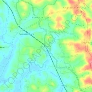
Name: Manjoor topographic map, elevation, terrain.
Location: Manjoor, Vaikom, Kottayam, Kerala, 686603, India (9.70870 76.49928 9.74870 76.53928)
Average elevation: 26 m
Minimum elevation: 0 m
Maximum elevation: 77 m
Thank you for supporting this site ❤️
Make a donation
Make a donation
Other topographic maps
Click on a map to view its topography, its elevation and its terrain.
Thank you for supporting this site ❤️
Make a donation
Make a donation
Arakkulam
India > Kerala > Vaikom > Thalayolaparambu > Chundangakari vadachira colony
Average elevation: 6 m