
Dadholi topographic map
Interactive map
Click on the map to display elevation.
About this map
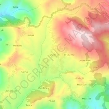
Name: Dadholi topographic map, elevation, terrain.
Location: Dadholi, Dwarahat, Almora District, Uttarakhand, 263654, India (29.73892 79.40748 29.77892 79.44748)
Average elevation: 1,449 m
Minimum elevation: 1,171 m
Maximum elevation: 1,690 m
Other topographic maps
Click on a map to view its topography, its elevation and its terrain.
bitholi
India > Uttarakhand > Dwarahat
bitholi, Dwarahat, Almora, Uttarakhand, 263653, India
Average elevation: 1,251 m