
Thank you for supporting this site ❤️
Make a donation
Make a donation
Schoolcraft County topographic map
Click on the map to display elevation.
Thank you for supporting this site ❤️
Make a donation
Make a donation
About this map
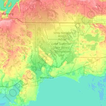
Name: Schoolcraft County topographic map, elevation, terrain.
Location: Schoolcraft County, Michigan, United States (45.75692 -86.61544 46.50584 -85.86441)
Average elevation: 217 m
Minimum elevation: 172 m
Maximum elevation: 330 m
Thank you for supporting this site ❤️
Make a donation
Make a donation
Other topographic maps
Click on a map to view its topography, its elevation and its terrain.