
Make a donation
Valencia topographic map
Click on the map to display elevation.
Make a donation
Valencia
The city's topography is characterized as flat to undulating hills with extensive plateaus and mountainous areas and cliffs on both eastern and western portions bounding the municipality of San Fernando on the east and the municipality of Talakag on the west. Its highest point is Mount Kalatungan in the Kalatungan Mountain Range rising above 1,000 meters and above 50 percent slopes. These cover 25.72 percent of the total city area and major portions of Barangay of Lourdes, Guinoyuran and Lilingayon.
Make a donation
About this map
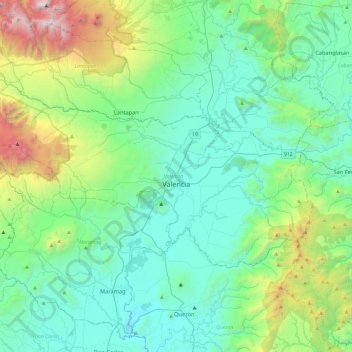
Name: Valencia topographic map, elevation, terrain.
Location: Valencia, Bukidnon, Northern Mindanao, 8709, Philippines (7.79163 124.80269 8.03586 125.27332)
Average elevation: 736 m
Minimum elevation: 182 m
Maximum elevation: 2,878 m
Make a donation
Other topographic maps
Click on a map to view its topography, its elevation and its terrain.
Valencia
The city's topography is characterized as flat to undulating hills with extensive plateaus and mountainous areas and cliffs on both eastern and western portions bounding the municipality of San Fernando on the east and the municipality of Talakag on the west. Its highest point is Mount Kalatungan in the…
Average elevation: 566 m
Make a donation
Make a donation
Make a donation
Make a donation
Impasugong
Philippines > Bukidnon > Impasugong
Cool and moist throughout the year due to its high elevation ranging from 500 metres (1,600 ft) to more than 1,000 metres (3,300 ft) above sea level. It is a typhoon-free area ideal for the production of high value crops. Average temperature ranges from 16 to 31 °C (61 to 88 °F) throughout the year.
Average elevation: 613 m
Make a donation
Don Carlos
Philippines > Bukidnon > Don Carlos
The terrain of the municipality of Don Carlos is generally flat except the mountain range on the eastern part of the municipality. The highest elevation is 700 metres (2,300 ft) above sea level and the lowest elevation is 300 metres (980 ft) below sea level.
Average elevation: 299 m
Make a donation
Make a donation
Make a donation
Make a donation
Lake Apo
Philippines > Bukidnon > Valencia
Lake Apo is a crater lake in Barangay Guinoyoran in the city of Valencia in Bukidnon province in the Philippines. It is located in a hilly area about 640 metres (2,100 ft) in elevation, about 11 kilometres (6.8 mi) WSW of the city poblacion (town center). Lake Apo was awarded the cleanest inland body of water…
Average elevation: 643 m
Make a donation
Make a donation
Make a donation
Make a donation
Make a donation
Make a donation
Make a donation
Make a donation
Make a donation
Make a donation
Make a donation
Make a donation
Make a donation
Make a donation
Mount Kitanglad
Philippines > Bukidnon > Impasugong
Due to its high elevation, several communications and broadcasting companies constructed relay stations at the summit.
Average elevation: 2,393 m
Make a donation
Make a donation