
Thank you for supporting this site ❤️
Make a donation
Make a donation
Rojgaon topographic map
Click on the map to display elevation.
Thank you for supporting this site ❤️
Make a donation
Make a donation
About this map
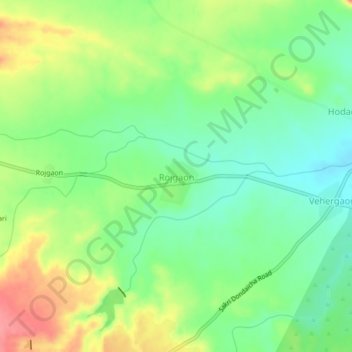
Name: Rojgaon topographic map, elevation, terrain.
Location: Rojgaon, Sakri Taluka, Dhule District, Maharashtra, India (21.08106 74.37020 21.12106 74.41020)
Average elevation: 406 m
Minimum elevation: 374 m
Maximum elevation: 454 m
Thank you for supporting this site ❤️
Make a donation
Make a donation