
Rich Hill topographic map
Interactive map
Click on the map to display elevation.
About this map
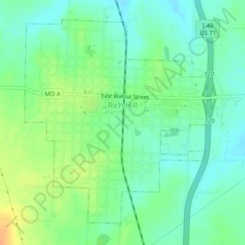
Name: Rich Hill topographic map, elevation, terrain.
Location: Rich Hill, Bates County, Missouri, 64779, United States (38.08312 -94.37478 38.10589 -94.34875)
Average elevation: 244 m
Minimum elevation: 231 m
Maximum elevation: 266 m
Other topographic maps
Click on a map to view its topography, its elevation and its terrain.
Amsterdam
United States > Missouri > Bates County
Amsterdam, Bates County, Missouri, United States
Average elevation: 273 m
Butler
United States > Missouri > Bates County
Butler, Bates County, Missouri, 64730, United States
Average elevation: 256 m
Adrian
United States > Missouri > Bates County
Adrian, Bates County, Missouri, 64720, United States
Average elevation: 262 m
Amoret
United States > Missouri > Bates County
Amoret, Bates County, Missouri, United States
Average elevation: 256 m
Rockville
United States > Missouri > Bates County
Rockville, Bates County, Missouri, United States
Average elevation: 232 m
Foster
United States > Missouri > Bates County
Foster, Bates County, Missouri, 64745, United States
Average elevation: 253 m
Passaic
United States > Missouri > Bates County
Passaic, Bates County, Missouri, United States
Average elevation: 264 m
Hudson
United States > Missouri > Bates County
Hudson, Bates County, Missouri, United States
Average elevation: 266 m
Merwin
United States > Missouri > Bates County
Merwin, Bates County, Missouri, United States
Average elevation: 282 m
Johnstown
United States > Missouri > Bates County
Johnstown, Bates County, Missouri, United States
Average elevation: 251 m
Altona
United States > Missouri > Bates County
Altona, Bates County, Missouri, United States
Average elevation: 260 m
Hume
United States > Missouri > Bates County
Hume, Bates County, Missouri, United States
Average elevation: 272 m