
Oslob topographic map
Interactive map
Click on the map to display elevation.
About this map
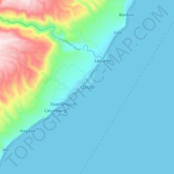
Name: Oslob topographic map, elevation, terrain.
Location: Oslob, Cebu, Central Visayas, Philippines (9.48045 123.39352 9.56045 123.47352)
Average elevation: 118 m
Minimum elevation: 0 m
Maximum elevation: 700 m
Generally, topography of the area is hilly and rolling, dominated by open grasslands and second growth forest. There are fairly level and rolling plateaus and valleys spread throughout the interior. These are some of the most suitable areas for upland agriculture. The highest mountain peak is 800 metres (2,600 ft) above sea level.
Other topographic maps
Click on a map to view its topography, its elevation and its terrain.
Cebu City
Philippines > Cebu > Cebu City
Cebu City, Cebu, Central Visayas, 6000, Philippines
Average elevation: 140 m
Dalaguete
Dalaguete, Cebu, Central Visayas, 6022, Philippines
Average elevation: 70 m
Uling
Philippines > Cebu > Naga
Uling, Naga, Cebu, Central Visayas, Philippines
Average elevation: 314 m
Busay
Philippines > Cebu > Moalboal
Busay, Moalboal, Cebu, Central Visayas, 6033, Philippines
Average elevation: 151 m
Maghaway
Philippines > Cebu > Talisay
Maghaway, Talisay, Cebu, Central Visayas, 6045, Philippines
Average elevation: 122 m
Boljoon River
Philippines > Cebu > Boljoon > Lower Becerril
Boljoon River, Poblacion, Lower Becerril, Boljoon, Cebu, Central Visayas, 6024, Philippines
Average elevation: 64 m
Cabungahan
Cabungahan, Cebu, Central Visayas, 6037, Philippines
Average elevation: 153 m
Malapascua
Philippines > Cebu > Logon
Malapascua, Logon, Cebu, Central Visayas, Philippines
Average elevation: 1 m
Day-as
Philippines > Cebu > Cordova
Day-as, Cordova, Cebu, Central Visayas, 6017, Philippines
Average elevation: 1 m
Mactan
Philippines > Cebu > Cordova
Mactan, Cordova, Cebu, Central Visayas, Philippines
Average elevation: 3 m
Toledo City Plaza
Philippines > Cebu > Toledo
Toledo City Plaza, Toledo, Cebu, Central Visayas, 6038, Philippines
Average elevation: 9 m
Minglanilla
Minglanilla, Cebu, Central Visayas, 6046, Philippines
Average elevation: 60 m
Luyang River
Philippines > Cebu > Carmen
Luyang River, Carmen, Cebu, Central Visayas, 6005, Philippines
Average elevation: 58 m
Guadalupe
Guadalupe, Cebu, Central Visayas, 6010, Philippines
Average elevation: 60 m
Daanbantayan
Philippines > Cebu > Daanbantayan
Daanbantayan, Cebu, Central Visayas, 6013, Philippines
Average elevation: 9 m
Bonbon
Philippines > Cebu > Bonbon
Bonbon, Cebu, Central Visayas, 6040, Philippines
Average elevation: 20 m
Bantayan Island
Philippines > Cebu > Bogo
Bantayan Island, Bogo, Cebu, Central Visayas, 6052, Philippines
Average elevation: 5 m
Hingatmonan
Philippines > Cebu > Hingatmonan
Hingatmonan, Cebu, Central Visayas, Philippines
Average elevation: 113 m
Prenza
Philippines > Cebu > Prenza
Prenza, Cebu, Central Visayas, 6041, Philippines
Average elevation: 40 m
New Bago
Philippines > Cebu > New Bago
New Bago, Cebu, Central Visayas, Philippines
Average elevation: 113 m
Mount Uling
Philippines > Cebu > Naga
Mount Uling, Naga, Cebu, Central Visayas, Philippines
Average elevation: 333 m
Mohou
Philippines > Cebu > Owak > Mohou
Mohou, Owak, Cebu, Central Visayas, Philippines
Average elevation: 15 m
Cadaatan
Philippines > Cebu > Cayang > Cadaatan
Cadaatan, Cayang, Cebu, Central Visayas, 6010, Philippines
Average elevation: 37 m