
Thank you for supporting this site ❤️
Make a donation
Make a donation
Buckfastleigh topographic map
Click on the map to display elevation.
Thank you for supporting this site ❤️
Make a donation
Make a donation
About this map
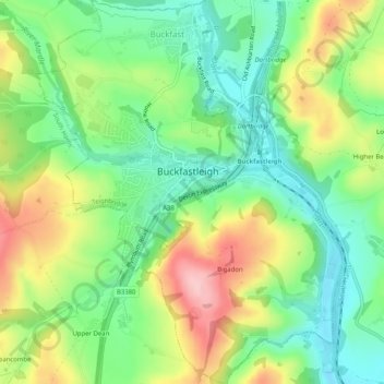
Name: Buckfastleigh topographic map, elevation, terrain.
Location: Buckfastleigh, Teignbridge, Devon, England, United Kingdom (50.46337 -3.79825 50.49562 -3.75766)
Average elevation: 85 m
Minimum elevation: 18 m
Maximum elevation: 189 m
Thank you for supporting this site ❤️
Make a donation
Make a donation
Other topographic maps
Click on a map to view its topography, its elevation and its terrain.
Haytor Rocks
United Kingdom > England > Devon > Teignbridge > Haytor Vale > Smallacombe
Average elevation: 354 m