
Thank you for supporting this site ❤️
Make a donation
Make a donation
Humphreys County topographic map
Click on the map to display elevation.
Thank you for supporting this site ❤️
Make a donation
Make a donation
About this map
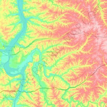
Name: Humphreys County topographic map, elevation, terrain.
Location: Humphreys County, Tennessee, United States (35.80370 -88.02525 36.24464 -87.53388)
Average elevation: 174 m
Minimum elevation: 103 m
Maximum elevation: 268 m
Thank you for supporting this site ❤️
Make a donation
Make a donation
Other topographic maps
Click on a map to view its topography, its elevation and its terrain.
Thank you for supporting this site ❤️
Make a donation
Make a donation
Thank you for supporting this site ❤️
Make a donation
Make a donation
Shepherd
United States > Tennessee > Hamilton County > Chattanooga > Shepherd
Average elevation: 212 m
Thank you for supporting this site ❤️
Make a donation
Make a donation