
Thank you for supporting this site ❤️
Make a donation
Make a donation
Bonneville County topographic map
Click on the map to display elevation.
Thank you for supporting this site ❤️
Make a donation
Make a donation
About this map
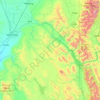
Name: Bonneville County topographic map, elevation, terrain.
Location: Bonneville County, Idaho, United States (43.01938 -112.51986 43.62691 -111.04400)
Average elevation: 1,963 m
Minimum elevation: 1,387 m
Maximum elevation: 4,011 m
Thank you for supporting this site ❤️
Make a donation
Make a donation
Other topographic maps
Click on a map to view its topography, its elevation and its terrain.