
Islamabad Capital Territory topographic map
Interactive map
Click on the map to display elevation.
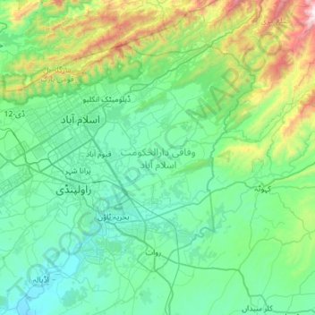
Islamabad Capital Territory topographic map, elevation, terrain
Islamabad Capital Territory
The temperatures range from 13 °C (55 °F) in January to 38 °C (100 °F) in June. The hottest month is June, where average highs routinely exceed 38 °C (100.4 °F), while the coolest month is January. The highest recorded temperature was 46.6 °C (115.9 °F) on 23 June 2005 while the lowest temperature was −6 °C (21.2 °F) on 17 January 1967. Winters generally feature dense fog in the mornings and sunny afternoons. In the city, temperatures stay mild, with snowfall over the higher elevations points on nearby hill stations, notably Murree and Nathia Gali.
About this map
Name: Islamabad Capital Territory topographic map, elevation, terrain.
Location: Islamabad Capital Territory, Pakistan (33.46810 72.81760 33.80328 73.37488)
Average elevation: 697 m
Minimum elevation: 381 m
Maximum elevation: 2,190 m
Other topographic maps
Click on a map to view its topography, its elevation and its terrain.
Rawat Fort
Pakistan > Islamabad Capital Territory > Rawalpindi District > Channi Alam Sher > Dhoke Shah Alam Khan Number Dar
Average elevation: 562 m
Vehari
Vehari also spelled Vihari (وِہاڑی), is a city and the headquarters of Vehari District in the Punjab province of Pakistan. It is Pakistan's 62nd largest city. Vehari is about 100 km (62 mi) from the historical city of Multan. Vehari is located at the Multan-Delhi Road constructed by Emperor Sher Shah…
Average elevation: 139 m
Harichand
Pakistan > Khyber Pakhtunkhwa > Charsadda District
Harichand is a town and union council in the Charsadda District of Khyber-Pakhtunkhwa. It is located at 34°23'2"N 71°48'18"E and has an altitude of 381 meters (1253 feet).
Average elevation: 410 m
Kohat
Pakistan > Khyber Pakhtunkhwa > Kohat District
Kohat city is located at an altitude of 489 metres (1,604 ft). Kohat Pass lies to the north. It is situated on the left bank of the Toi river at a point where after running nearly due east for 50 miles (80 km), it turns to the south. The total area of the district is 2,545 square kilometres (983 sq mi)
Average elevation: 722 m
Mardan
Pakistan > Khyber Pakhtunkhwa > Mardan District
Mardan is located in the south west of the district at 34°12'0N 72°1'60E and an altitude of 283 metres (928 ft). Mardan is a district headquarter of Mardan District of Khyber Pakhtunkhwa. Risalpur is located to the south, Charsadda is located to the west, Yar Hussain to the east and Takht Bahi & Katlang to…
Average elevation: 328 m
Timergara
Pakistan > Khyber Pakhtunkhwa > Lower Dir District
Timergara (Pashto: تيمرګره, Urdu: تیمرگرہ) is a city and the district headquarters of the Lower Dir District and temporary headquarter of newly established Central Dir District in Khyber Pakhtunkhwa, Pakistan. Timergara city is located on the east bank of the Panjkora River. It lies at an…
Average elevation: 922 m
Dera Ismail Khan
Pakistan > Khyber Pakhtunkhwa > Dera Ismail Khan District
D. I Khan is situated at an altitude of 177 metres above sea level.
Average elevation: 177 m