
Almaty Region topographic map
Interactive map
Click on the map to display elevation.
About this map
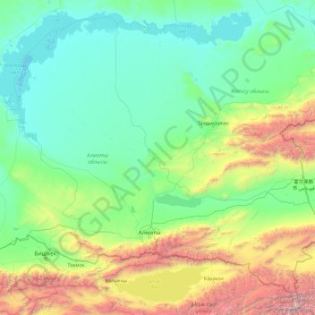
Name: Almaty Region topographic map, elevation, terrain.
Location: Almaty Region, Kazakhstan (42.21084 73.72202 46.73814 80.80728)
Average elevation: 1,137 m
Minimum elevation: 335 m
Maximum elevation: 7,318 m
Other topographic maps
Click on a map to view its topography, its elevation and its terrain.
Border Kazakhstan - Russia
Kazakhstan > East Kazakhstan Region > Katonkaragay District
Average elevation: 2,676 m
Кордон номер четыре аксы-арасанского лесничества
Average elevation: 1,129 m