
Make a donation
Merrimack County topographic map
Click on the map to display elevation.
Make a donation
About this map
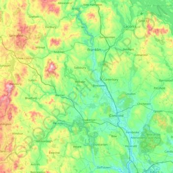
Name: Merrimack County topographic map, elevation, terrain.
Location: Merrimack County, New Hampshire, United States (43.00930 -72.08839 43.61122 -71.23520)
Average elevation: 251 m
Minimum elevation: 49 m
Maximum elevation: 880 m
Make a donation
Other topographic maps
Click on a map to view its topography, its elevation and its terrain.
Make a donation
Make a donation
Mount Washington
United States > New Hampshire > Coos County
Mount Washington, in New Hampshire, is the highest peak in the Northeastern United States at 6,288.2 ft (1,916.6 m) and the most topographically prominent mountain east of the Mississippi River.
Average elevation: 1,568 m
Winnipesaukee
United States > New Hampshire > Carroll County > Moultonborough
Average elevation: 161 m
Mount Adams
United States > New Hampshire > Coos County
Mount Adams, elevation 5,793 feet (1,766 m) above sea level, is a mountain in New Hampshire, the second highest peak in the Northeast United States after its nearby neighbor, Mount Washington. Located in the northern Presidential Range, Mount Adams was named after John Adams, the second President of the United…
Average elevation: 1,379 m
Make a donation
Make a donation
Make a donation
Streeter Mountain
United States > New Hampshire > Grafton County > Dorchester
Average elevation: 449 m
Make a donation
Stone Pond
United States > New Hampshire > Cheshire County > Marlow > Gee Mill
Average elevation: 430 m
Make a donation
Souhegan River
United States > New Hampshire > Hillsborough County > Milford > East Milford
Average elevation: 84 m
The Village of Loon Mountain
United States > New Hampshire > Grafton County > Lincoln
Average elevation: 532 m
Make a donation
Mount Monadnock
United States > New Hampshire > Cheshire County > Jaffrey
From the base to the summit, floral species diminish with increasingly shallow soil levels. The summit is home to many different specialized sub-alpine species which can retain moisture for long periods of time. Alpine and sub-alpine species include mountain ash, cotton grass, sheep laurel, mountain sandwort,…
Average elevation: 687 m
Make a donation
Joe English Hill
United States > New Hampshire > Hillsborough County > New Boston
Average elevation: 247 m
Governors Island
United States > New Hampshire > Belknap County > Gilford > Dockham Shore
Average elevation: 162 m
Make a donation
Diamond Island
United States > New Hampshire > Belknap County > Gilford > Coleman Point
Average elevation: 154 m
Rattlesnake Island
United States > New Hampshire > Belknap County > Alton
Rattlesnake Island is about 2 miles (3 km) long, and approximately 5 miles (8 km) around its shore. The topography varies greatly. Some sections of the island are quite steep, with the land rising steeply from the shore (affording views of the area), while other sections, particularly on the "peninsula", which…
Average elevation: 159 m
Make a donation
Souhegan River Watershed Dam Number 35
United States > New Hampshire > Hillsborough County > New Ipswich > Smithville
Average elevation: 349 m
Piscataquog River
United States > New Hampshire > Hillsborough County > Manchester
Average elevation: 59 m
Make a donation
South Uncanoonuc Mountain
United States > New Hampshire > Hillsborough County > Goffstown
Average elevation: 243 m
Make a donation
Kolelemook Lake
United States > New Hampshire > Sullivan County > Springfield
Average elevation: 463 m
Make a donation
Center Strafford
United States > New Hampshire > Strafford County > Strafford
Average elevation: 148 m
New Ipswich Center
United States > New Hampshire > Hillsborough County > New Ipswich
Average elevation: 324 m
Make a donation
North Charlestown
United States > New Hampshire > Sullivan County > Charlestown
Average elevation: 162 m
South Charlestown
United States > New Hampshire > Sullivan County > Charlestown
Average elevation: 153 m
Make a donation
Halfmoon Lake
United States > New Hampshire > Belknap County > Barnstead > Fernhill
Average elevation: 213 m
Little Bear Island
United States > New Hampshire > Carroll County > Tuftonboro
Average elevation: 160 m
Make a donation
Black Cat Island
United States > New Hampshire > Carroll County > Moultonborough
Average elevation: 156 m
Make a donation
Nineacre Island
United States > New Hampshire > Carroll County > Moultonborough
Average elevation: 158 m
Make a donation
Whortleberry Island
United States > New Hampshire > Carroll County > Tuftonboro > Chase Point
Average elevation: 156 m
Sleepers Island
United States > New Hampshire > Belknap County > Alton > Smith Point
Average elevation: 163 m
Cow Island
United States > New Hampshire > Carroll County > Tuftonboro > Fox Point
Average elevation: 162 m
Make a donation
South Beacon Shoal
United States > New Hampshire > Rockingham County > Portsmouth
Average elevation: 4 m
Hampton River
United States > New Hampshire > Rockingham County > Hampton Falls
Average elevation: 1 m
Make a donation
Catamount Mountain
United States > New Hampshire > Merrimack County > Pittsfield
Average elevation: 281 m
New Durham Corner
United States > New Hampshire > Strafford County > New Durham
Average elevation: 184 m
Bow Lake Village
United States > New Hampshire > Strafford County > Strafford
Average elevation: 174 m
Make a donation
Make a donation
Gilmanton Ironworks
United States > New Hampshire > Belknap County > Gilmanton
Average elevation: 224 m
Mount Washington
United States > New Hampshire > Coos County
Mount Washington, also known as Agiocochook, is an ultra-prominent mountain in the state of New Hampshire. It is the highest peak in the Northeastern United States at 6,288.2 ft (1,916.6 m) and the most topographically prominent mountain east of the Mississippi River.
Average elevation: 1,568 m
Make a donation
Fitzwilliam Depot
United States > New Hampshire > Cheshire County > Fitzwilliam
Average elevation: 349 m
Make a donation