Geolocate

Mapua topographic map

Interactive map

Click on the map to display elevation.

About this map

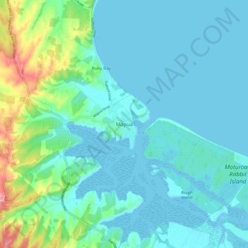
Name: Mapua topographic map, elevation, terrain.

Location: Mapua, Tasman, 7005, New Zealand (-41.29321 173.05622 -41.21321 173.13622)

Average elevation: 23 m

Minimum elevation: -1 m

Maximum elevation: 136 m

Tasman trails, hiking, mountain biking, running and outdoor activities

Other topographic maps

Click on a map to view its topography, its elevation and its terrain.

Lake Rotoiti

New Zealand > Tasman > Saint Arnaud

Average elevation: 1,031 m

Golden Bay

New Zealand > Tasman > Tasman District

Average elevation: 43 m

Nelson Lakes National Park

New Zealand > Tasman

Average elevation: 1,098 m

Maruia River

New Zealand > Tasman

Average elevation: 760 m

Mārahau River

New Zealand > Tasman > Marahau

Average elevation: 245 m

Tonga Island

New Zealand > Tasman

Average elevation: 9 m

Abel Tasman National Park

New Zealand > Tasman > Anatimo

Average elevation: 271 m

Takaka River

New Zealand > Tasman

Average elevation: 832 m

Onekaka River

New Zealand > Tasman

Average elevation: 55 m