
Waitara topographic map
Interactive map
Click on the map to display elevation.
About this map
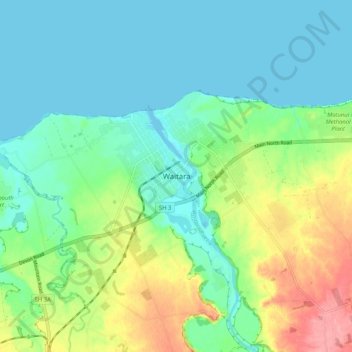
Name: Waitara topographic map, elevation, terrain.
Average elevation: 28 m
Minimum elevation: -1 m
Maximum elevation: 96 m
Other topographic maps
Click on a map to view its topography, its elevation and its terrain.
New Plymouth
New Zealand > Taranaki > New Plymouth District
New Plymouth, New Plymouth District, Taranaki, 4310, New Zealand
Average elevation: 92 m
Urenui
New Zealand > Taranaki > New Plymouth District
Urenui, New Plymouth District, Taranaki, New Zealand
Average elevation: 137 m
Ōakura River
New Zealand > Taranaki > New Plymouth District > Oakura
Ōakura River, Ōakura, New Plymouth District, Taranaki, New Zealand
Average elevation: 255 m
Mangorei
New Zealand > Taranaki > New Plymouth District > New Plymouth
Mangorei, New Plymouth, New Plymouth District, Taranaki, 4371, New Zealand
Average elevation: 90 m
Mount Messenger
New Zealand > Taranaki > New Plymouth District
Mount Messenger, New Plymouth District, Taranaki, 4378, New Zealand
Average elevation: 128 m
Pouakai Reflective Tarn
New Zealand > Taranaki > New Plymouth District
Pouakai Reflective Tarn, New Plymouth District, Taranaki, New Zealand
Average elevation: 1,009 m
Tapuae Stream
New Zealand > Taranaki > New Plymouth District > Oakura
Tapuae Stream, Oakura, New Plymouth District, Taranaki, 4374, New Zealand
Average elevation: 108 m
Okato
New Zealand > Taranaki > New Plymouth District
Okato, New Plymouth District, Taranaki, 4335, New Zealand
Average elevation: 98 m