
Sheridan County topographic map
Interactive map
Click on the map to display elevation.
About this map
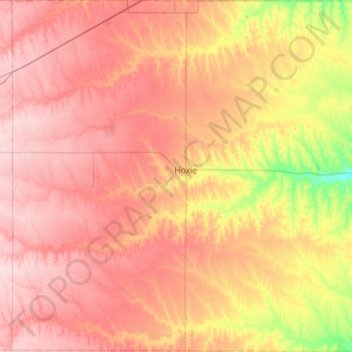
Name: Sheridan County topographic map, elevation, terrain.
Location: Sheridan County, Kansas, United States (39.13189 -100.72156 39.56846 -100.16345)
Average elevation: 840 m
Minimum elevation: 729 m
Maximum elevation: 919 m
Other topographic maps
Click on a map to view its topography, its elevation and its terrain.
Everest
United States > Kansas > Brown County
Everest, Brown County, Kansas, United States
Average elevation: 346 m
Solomon
United States > Kansas > Dickinson County
Solomon, Dickinson County, Kansas, United States
Average elevation: 364 m
Eastborough
United States > Kansas > Sedgwick County
Eastborough, Sedgwick County, Kansas, United States
Average elevation: 416 m
Lebanon
United States > Kansas > Smith County
Lebanon, Smith County, Kansas, 66952, United States
Average elevation: 558 m
Saint Marys
United States > Kansas > Pottawatomie County
Saint Marys, Pottawatomie County, Kansas, United States
Average elevation: 302 m
Lawrence
United States > Kansas > Douglas County
Lawrence, Douglas County, Kansas, United States
Average elevation: 265 m
Overland Park
United States > Kansas > Johnson County > Overland Park
Overland Park, Johnson County, Kansas, 66204, United States
Average elevation: 288 m
Wichita
United States > Kansas > Wichita
Wichita, Sedgwick County, Kansas, United States
Average elevation: 408 m
Athol
United States > Kansas > Smith County
Athol, Smith County, Kansas, United States
Average elevation: 548 m
Derby
United States > Kansas > Derby
Derby, Sedgwick County, Kansas, United States
Average elevation: 392 m
Smith County
United States > Kansas > Smith County
Smith County, Kansas, United States
Average elevation: 557 m