
Lemhi County topographic map
Interactive map
Click on the map to display elevation.
About this map
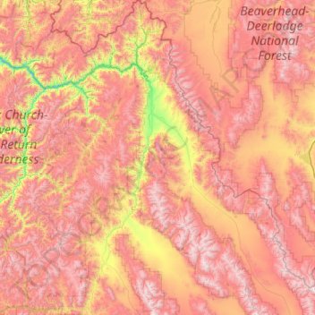
Name: Lemhi County topographic map, elevation, terrain.
Location: Lemhi County, Idaho, United States of America (44.22987 -114.82012 45.70598 -112.81246)
Average elevation: 2,146 m
Minimum elevation: 971 m
Maximum elevation: 3,412 m
Other topographic maps
Click on a map to view its topography, its elevation and its terrain.
Twin Falls County
United States of America > Idaho
Twin Falls County, Idaho, United States of America
Average elevation: 1,404 m
Shoshone County
United States of America > Idaho
Shoshone County, Idaho, United States of America
Average elevation: 1,204 m
Boise
United States of America > Idaho > Boise
Boise, Ada County, Idaho, United States of America
Average elevation: 974 m
Springston
United States of America > Idaho > Springston
Springston, Kootenai County, Idaho, 83833, United States of America
Average elevation: 721 m