
Twin Falls County topographic map
Interactive map
Click on the map to display elevation.
About this map
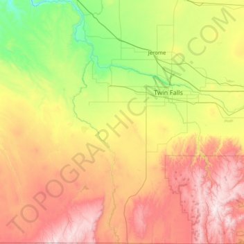
Name: Twin Falls County topographic map, elevation, terrain.
Location: Twin Falls County, Idaho, United States of America (41.99421 -115.03959 42.91954 -114.00994)
Average elevation: 1,404 m
Minimum elevation: 787 m
Maximum elevation: 2,449 m
Other topographic maps
Click on a map to view its topography, its elevation and its terrain.
Shoshone County
United States of America > Idaho
Shoshone County, Idaho, United States of America
Average elevation: 1,204 m
Boise
United States of America > Idaho > Boise
Boise, Ada County, Idaho, United States of America
Average elevation: 974 m
Lemhi County
United States of America > Idaho
Lemhi County, Idaho, United States of America
Average elevation: 2,146 m
Springston
United States of America > Idaho > Springston
Springston, Kootenai County, Idaho, 83833, United States of America
Average elevation: 721 m