
Make a donation
Lechlade topographic map
Click on the map to display elevation.
Make a donation
About this map
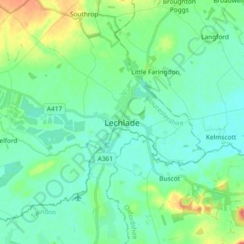
Name: Lechlade topographic map, elevation, terrain.
Average elevation: 81 m
Minimum elevation: 67 m
Maximum elevation: 126 m
Make a donation
Other topographic maps
Click on a map to view its topography, its elevation and its terrain.
Clearwater
United Kingdom > England > Gloucestershire > Cotswold District > Somerford Keynes
Average elevation: 88 m
Aston Subedge
United Kingdom > England > Gloucestershire > Cotswold District > Weston-sub-Edge
Average elevation: 101 m
Moreton-in-Marsh
United Kingdom > England > Gloucestershire > Cotswold District
Average elevation: 135 m
Make a donation
Cold Aston
United Kingdom > England > Gloucestershire > Cotswold District > Cold Aston
Average elevation: 189 m
Coberley
United Kingdom > England > Gloucestershire > Cotswold District > Coberley
Average elevation: 234 m
Fairford
United Kingdom > England > Gloucestershire > Cotswold District > Fairford
Average elevation: 98 m