
Blackstone Hill topographic map
Interactive map
Click on the map to display elevation.
About this map
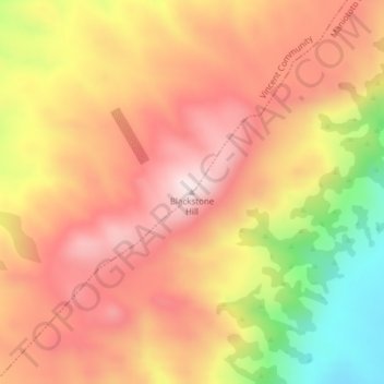
Name: Blackstone Hill topographic map, elevation, terrain.
Average elevation: 789 m
Minimum elevation: 480 m
Maximum elevation: 984 m
Routes: Central Otago District GPS tracks, routes, trails, hikes
Other topographic maps
Click on a map to view its topography, its elevation and its terrain.
Clyde Dam
New Zealand > Otago > Central Otago District > Vincent Community > Clyde
Average elevation: 318 m
Blue Lake
New Zealand > Otago > Central Otago District > Vincent Community > Saint Bathans
Average elevation: 605 m
Central Otago
New Zealand > Otago > Central Otago District > Vincent Community
Average elevation: 935 m
Muttontown
New Zealand > Otago > Central Otago District > Vincent Community > Clyde
Average elevation: 207 m