Geolocate

Victoria Daly Region topographic map

Interactive map

Click on the map to display elevation.

About this map

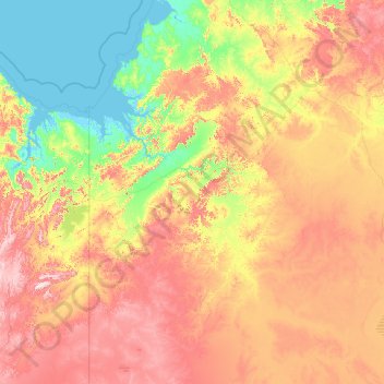
Name: Victoria Daly Region topographic map, elevation, terrain.

Location: Victoria Daly Region, Northern Territory, Australia (-18.68312 129.00045 -13.17573 132.52288)

Average elevation: 189 m

Minimum elevation: -2 m

Maximum elevation: 683 m

Other topographic maps

Click on a map to view its topography, its elevation and its terrain.

Brisbane

Australia > Queensland > Brisbane

Average elevation: 45 m

Logan City

Australia > Queensland > Logan City

Average elevation: 30 m

Moreton Bay

Australia > Queensland

Average elevation: 0 m

Manor Lake

Australia > Victoria > Melbourne

Average elevation: 45 m

Kangaroo Lake

Australia > Victoria

Average elevation: 77 m

Cessnock

Australia > New South Wales

Average elevation: 142 m

North Canberra

Australia

Average elevation: 606 m

Budj Bim

Australia > Victoria

Average elevation: 106 m

Lions head

Australia > New South Wales

Average elevation: 439 m

Cape Le Grand

Australia > Western Australia

Average elevation: 21 m

Skinners Park

Australia > Queensland

Average elevation: 10 m

Mount Wellington

Australia > Tasmania

"... In many parts the Eucalypti grew to a great size, and composed a noble forest. In some of the dampest ravines, tree-ferns flourished in an extraordinary manner; I saw one which must have been at least twenty feet high to the base of the fronds, and was in girth exactly six feet. The fronds forming the…

Average elevation: 941 m

Awoonga Dam

Australia > Queensland > Benaraby

Average elevation: 42 m

Mount Glorious

Australia > Queensland

Average elevation: 486 m

Mount MacDonald

Australia > Western Australia

Average elevation: 488 m

Satur

Australia > New South Wales > Scone

Average elevation: 213 m

The Black Mountain

Australia > New South Wales

Average elevation: 1,208 m

Hastings Caves

Australia > Tasmania > Hastings

Average elevation: 242 m

Snapper Rock

Australia > Victoria

Average elevation: 4 m

Finch Hatton

Australia > Queensland

Average elevation: 226 m

Mount Arthur

Australia > Queensland

Average elevation: 223 m

Mount Grand

Australia > Victoria > Melbourne

Average elevation: 80 m

Buxton

Australia > Victoria

Average elevation: 318 m

Mount Selwyn

Australia > New South Wales

Average elevation: 1,523 m

Clarks Beach

Australia > Tasmania > Hobart

Average elevation: 32 m

Esquiline Hill

Australia > Queensland

Average elevation: 26 m

Lark Hill

Australia > Western Australia

Average elevation: 9 m

Anzac Park

Australia > New South Wales > Sydney

Average elevation: 45 m

Torres Strait

Australia > Queensland

Several clusters of islands lie in the Strait, collectively called the Torres Strait Islands. There are at least 274 of these islands, of which 17 have present-day permanent settlements. These islands have a variety of topographies, ecosystems and formation history. Several of those closest to the New Guinea…

Average elevation: 0 m

Nobbys Beach

Australia > New South Wales > Newcastle

Average elevation: 3 m

Hexam Vale

Australia > New South Wales

Average elevation: 549 m

Macleay Island

Australia > Western Australia

Average elevation: 4 m

Wondai

Australia > Queensland

Average elevation: 337 m

Mount Annan

Australia > New South Wales > Sydney

Average elevation: 115 m

Dandenong Ranges

Australia > Victoria > Melbourne

The topography consists of a series of ridges dissected by deeply cut streams. Sheltered gullies in the south of the range are home to temperate rain forest, fern gullies and Mountain Ash forest Eucalyptus regnans, whereas the drier ridges and exposed northern slopes are covered by dry sclerophyll forest of…

Average elevation: 456 m

Broughton Island

Australia > New South Wales

Average elevation: 3 m

Lake Heron

Australia > Queensland > Gold Coast City

Average elevation: 4 m

Macleay Island

Australia > Queensland

Average elevation: 3 m

Airlie Beach

Australia > Queensland > Airlie Beach

Average elevation: 81 m

Colo River

Australia > New South Wales

Average elevation: 337 m

Tewantin

Australia > Queensland > Tewantin

Average elevation: 11 m

Coomalbidgup

Australia > Western Australia

Average elevation: 63 m

Nambour

Australia > Queensland > Nambour

Average elevation: 59 m

Lake Mountain

Australia > Victoria

Average elevation: 1,288 m

Kenilworth

Australia > Queensland > Kenilworth

Average elevation: 159 m

Cooroy

Australia > Queensland

Average elevation: 120 m

One Tree Point

Australia

Average elevation: 286 m

Alice Springs

Australia > Northern Territory > Alice Springs

Temperatures in Alice Springs vary widely, and rainfall can vary quite dramatically from year to year. In summer, the average maximum temperature is in the mid-30s, whereas in winter the average minimum temperature can be 5.5 °C (41.9 °F), with an average of 12.4 nights below freezing every year, providing…

Average elevation: 631 m

Burnt Pine

Australia

Average elevation: 46 m

Hutt River

Australia > Western Australia

Average elevation: 191 m

Tiaro

Australia > Queensland > Tiaro

Average elevation: 40 m

Perth

Australia > Western Australia > City of Perth

Perth, the capital of Western Australia, is situated on the Swan Coastal Plain, a flat expanse of sandy soil nestled between the Indian Ocean to the west and the Darling Scarp to the east. The Darling Scarp, also known as the Darling Range, is a low escarpment that extends north–south, marking a distinct…

Average elevation: 26 m

Blue Mountains

Australia > New South Wales

A sandstone plateau dominated by a landscape of endless eucalyptus forests, the Blue Mountains are located at the top of a 470-million-year-old quartzite. In the Permian period, a shallow sea covered the region, when rivers brought shales, siltstones and mudstones. Then during the Mesozoic period, rivers…

Average elevation: 566 m

Snake Valley

Australia > Victoria

Average elevation: 410 m

Tully

Australia > Queensland > Tully

Average elevation: 119 m

Metung

Australia > Victoria

Average elevation: 9 m

Wattle Glen

Australia > Victoria > Melbourne > Wattle Glen

Average elevation: 121 m

Kalgoorlie

Australia > Western Australia

Average elevation: 360 m

Conondale

Australia > Queensland > Conondale

Average elevation: 156 m

Styx Creek

Australia > New South Wales

Average elevation: 35 m

Clarkes Beach

Australia > New South Wales > Byron Bay

Average elevation: 5 m

Coolum Beach

Australia > Queensland > Coolum Beach

Average elevation: 5 m

Wyndham

Australia > Western Australia > Wyndham

Average elevation: 24 m

Imbil

Australia > Queensland > Imbil

Average elevation: 109 m

Melbourne

Australia > Victoria > Melbourne

Melbourne is also prone to isolated convective showers forming when a cold pool crosses the state, especially if there is considerable daytime heating. These showers are often heavy and can include hail, squalls, and significant drops in temperature, but they often pass through very quickly with a rapid…

Average elevation: 49 m

Gosses Bluff North

Australia

Average elevation: 755 m

Bunbury

Australia > Western Australia > Bunbury

Average elevation: 14 m

Cooktown

Australia > Queensland

Average elevation: 22 m

Cairns

Australia > Queensland

South of Smithfield and inland from the Northern Beaches along the edge of the Barron River flood plain are the suburbs of Caravonica, Kamerunga, Freshwater, and Stratford. This area is sometimes referred to as Freshwater Valley, though it is actually the lower part of Redlynch Valley; further up the valley…

Average elevation: 176 m

Giru

Australia > Queensland > Giru

Average elevation: 5 m

Mount Baranduda

Australia > Victoria > Wodonga

Average elevation: 570 m

Beachhaven Park

Australia > Western Australia > Yanchep

Average elevation: 16 m

Adaminaby

Australia > New South Wales > Adaminaby

Average elevation: 1,038 m

Denmark

Australia > Western Australia > Denmark

Average elevation: 39 m

Brooklands

Australia > Queensland > Brooklands

Average elevation: 391 m

Mutitjulu

Australia > Northern Territory > Mutitjulu

Average elevation: 532 m

Belgravia

Australia > New South Wales > Belgravia

Average elevation: 285 m

Geraldton

Australia > Western Australia

Average elevation: 33 m

Fremantle

Australia > Western Australia > Fremantle

Average elevation: 11 m

Broken River

Australia > Queensland

Average elevation: 868 m

Devonport

Australia > Tasmania > Devonport

Average elevation: 67 m

Aubrey

Australia > Victoria > Aubrey

Average elevation: 114 m

Maldon

Australia > Victoria > Maldon

Average elevation: 326 m

Bundaberg

Australia > Queensland > Bundaberg Region

Average elevation: 18 m

Binalong Bay

Australia > Tasmania > Binalong Bay

Average elevation: 23 m

Newcastle

Australia > New South Wales > Newcastle

Average elevation: 9 m