
Barnsley topographic map
Interactive map
Click on the map to display elevation.
About this map
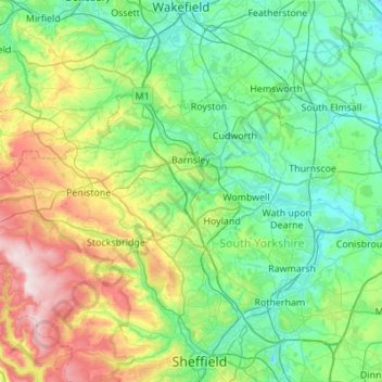
Name: Barnsley topographic map, elevation, terrain.
Location: Barnsley, Yorkshire and the Humber, England, United Kingdom (53.43830 -1.82259 53.61267 -1.27571)
Average elevation: 139 m
Minimum elevation: 8 m
Maximum elevation: 547 m
Other topographic maps
Click on a map to view its topography, its elevation and its terrain.
Darfield
United Kingdom > England > Barnsley
Darfield, Barnsley, South Yorkshire, England, S73 9AB, United Kingdom
Average elevation: 43 m