
Thank you for supporting this site ❤️
Make a donation
Make a donation
Bruton topographic map
Click on the map to display elevation.
Thank you for supporting this site ❤️
Make a donation
Make a donation
About this map
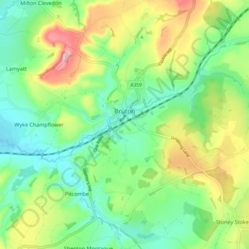
Name: Bruton topographic map, elevation, terrain.
Location: Bruton, Somerset, England, United Kingdom (51.08423 -2.50174 51.13421 -2.41497)
Average elevation: 105 m
Minimum elevation: 45 m
Maximum elevation: 214 m
Thank you for supporting this site ❤️
Make a donation
Make a donation
Other topographic maps
Click on a map to view its topography, its elevation and its terrain.