
Thank you for supporting this site ❤️
Make a donation
Make a donation
Soengas topographic map
Click on the map to display elevation.
Thank you for supporting this site ❤️
Make a donation
Make a donation
About this map
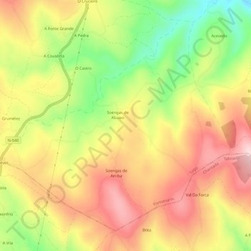
Name: Soengas topographic map, elevation, terrain.
Location: Soengas, Portomarín, Lugo, Galicia, 27214, España (42.77326 -7.75267 42.80652 -7.69873)
Average elevation: 615 m
Minimum elevation: 454 m
Maximum elevation: 745 m
Thank you for supporting this site ❤️
Make a donation
Make a donation
Other topographic maps
Click on a map to view its topography, its elevation and its terrain.