
Bagua Grande topographic map
Interactive map
Click on the map to display elevation.
About this map
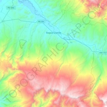
Name: Bagua Grande topographic map, elevation, terrain.
Location: Bagua Grande, Provincia de Utcubamba, Amazonas, Perú (-6.00539 -78.59715 -5.64405 -78.27784)
Average elevation: 1,250 m
Minimum elevation: 384 m
Maximum elevation: 3,004 m
Other topographic maps
Click on a map to view its topography, its elevation and its terrain.
Morropon
Perú > Amazonas > Bagua Grande
Morropon, Bagua Grande, Utcubamba, Amazonas, Perú
Average elevation: 562 m
Cerro Azul
Perú > Amazonas > Bagua Grande > Cerro Azul
Cerro Azul, Bagua Grande, Provincia de Utcubamba, Amazonas, Perú
Average elevation: 2,159 m