
Thank you for supporting this site ❤️
Make a donation
Make a donation
Awakino topographic map
Click on the map to display elevation.
Thank you for supporting this site ❤️
Make a donation
Make a donation
About this map
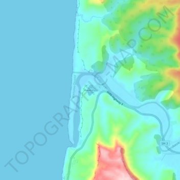
Name: Awakino topographic map, elevation, terrain.
Location: Awakino, Waitomo District, Waikato, New Zealand (-38.67277 174.60569 -38.63277 174.64569)
Average elevation: 37 m
Minimum elevation: -2 m
Maximum elevation: 239 m
Waitomo District trails, hiking, mountain biking, running and outdoor activities
Thank you for supporting this site ❤️
Make a donation
Make a donation
Other topographic maps
Click on a map to view its topography, its elevation and its terrain.