
Thank you for supporting this site ❤️
Make a donation
Make a donation
Glen Ellen topographic map
Click on the map to display elevation.
Thank you for supporting this site ❤️
Make a donation
Make a donation
About this map
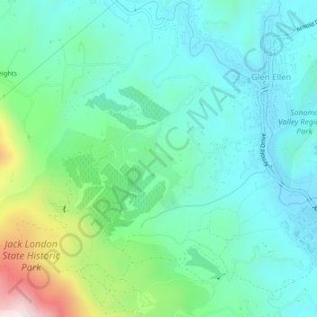
Name: Glen Ellen topographic map, elevation, terrain.
Location: Glen Ellen, Sonoma County, California, United States (38.33927 -122.56286 38.37182 -122.52125)
Average elevation: 188 m
Minimum elevation: 58 m
Maximum elevation: 606 m
Thank you for supporting this site ❤️
Make a donation
Make a donation
Other topographic maps
Click on a map to view its topography, its elevation and its terrain.