
Make a donation
Garrett County topographic map
Click on the map to display elevation.
Make a donation
Garrett County
Garrett County lies in the Allegheny Mountains, which here form the western flank of the Appalachian Mountain Range. Hoye-Crest, a summit along Backbone Mountain, is the highest point in Maryland at an elevation of 3,360 feet (1,020 m).
Make a donation
About this map
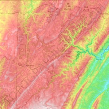
Name: Garrett County topographic map, elevation, terrain.
Location: Garrett County, Maryland, United States (39.20193 -79.48731 39.72278 -78.92843)
Average elevation: 700 m
Minimum elevation: 217 m
Maximum elevation: 1,092 m
Make a donation
Other topographic maps
Click on a map to view its topography, its elevation and its terrain.
Make a donation
Make a donation
Piscataway Hills
United States > Maryland > Prince George's County > Fort Washington
Average elevation: 26 m
Make a donation
Capitol Heights
United States > Maryland > Prince George's County > Capitol Heights > Capitol Heights
Average elevation: 51 m
Stoney Creek Pond
United States > Maryland > Montgomery County > Bethesda > Glenwood
Average elevation: 100 m