
Midi-Pyrénées topographic map
Interactive map
Click on the map to display elevation.
About this map
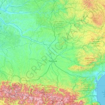
Name: Midi-Pyrénées topographic map, elevation, terrain.
Location: Midi-Pyrénées, Metropolitan France, France (42.57324 -0.32723 45.04664 3.45205)
Average elevation: 508 m
Minimum elevation: -2 m
Maximum elevation: 3,311 m
Other topographic maps
Click on a map to view its topography, its elevation and its terrain.
Barricata
France > Nouvelle-Aquitaine > Pyrénées-Atlantiques > Aussurucq > Etxakokua
Average elevation: 260 m
Basse-Bretagne
France > Centre-Val de Loire > Indre-et-Loire > Château-la-Vallière
Average elevation: 89 m
La Patte au Loup
France > Centre-Val de Loire > Indre-et-Loire > Chouzé-sur-Loire
Average elevation: 31 m