
Make a donation
Waipahu topographic map
Click on the map to display elevation.
Make a donation
Waipahu
There are several streams that run through Waipahu, including Waikele Stream and Kapakahi Stream. Waikele Stream runs along the Hawaii Plantation Village and down into Pouhala Marsh Wildlife Sanctuary, which is habitat for several endangered bird species that are endemic to Hawaii. There is roughly 140 feet of elevation change between the north side of Waipahu along H-1 and sea level.
Make a donation
About this map
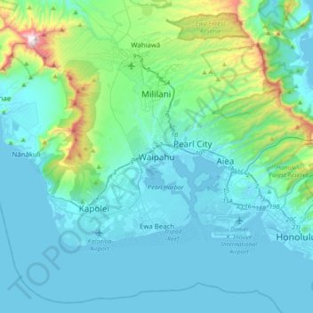
Name: Waipahu topographic map, elevation, terrain.
Location: Waipahu, Honolulu County, Hawaii, 96797, United States (21.22667 -158.16917 21.54667 -157.84917)
Average elevation: 164 m
Minimum elevation: -8 m
Maximum elevation: 1,221 m
Make a donation
Other topographic maps
Click on a map to view its topography, its elevation and its terrain.
Oʻahu
United States > Hawaii > Honolulu County
Oʻahu exhibits a striking and diverse topography shaped primarily by its volcanic origins and subsequent erosion. The island features a rugged landscape dominated by two prominent volcanic mountains, Koʻolau and Waiʻanae, which rise sharply from the coastline, reaching elevations of approximately 4,000…
Average elevation: 79 m
Make a donation
Waimānalo Beach Park
United States > Hawaii > Honolulu County > East Honolulu > Waimanalo
Average elevation: 55 m
Make a donation
Make a donation
Make a donation
Pearl Harbor National Memorial
United States > Hawaii > Honolulu County > Waipahu
Average elevation: 9 m
Palolo Valley Recreational Park
United States > Hawaii > Honolulu County > East Honolulu
Average elevation: 144 m
Make a donation
Make a donation
Make a donation
Make a donation
Make a donation
Make a donation
Koko Head District Park
United States > Hawaii > Honolulu County > East Honolulu
Average elevation: 47 m
Make a donation
Make a donation
Make a donation
Make a donation
Make a donation
Make a donation
Make a donation