
Make a donation
New Mexico topographic map
Click on the map to display elevation.
Make a donation
New Mexico
New Mexico is a state in the Southwestern region of the United States. It is one of the Mountain States of the southern Rocky Mountains, sharing the Four Corners region with Utah, Colorado, and Arizona. It also borders the state of Texas to the east and southeast, Oklahoma to the northeast, and shares an international border with the Mexican states of Chihuahua and Sonora to the south. New Mexico's largest city is Albuquerque, and its state capital is Santa Fe, the oldest state capital in the U.S., founded in 1610 as the government seat of Nuevo México in New Spain. It also has the highest elevation of any state capital, at 6,998 feet (2,133 m).
Make a donation
About this map
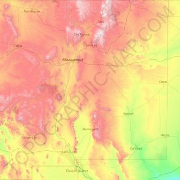
Name: New Mexico topographic map, elevation, terrain.
Location: New Mexico, United States (31.33220 -109.05022 37.00018 -103.00223)
Average elevation: 1,687 m
Minimum elevation: 742 m
Maximum elevation: 3,823 m
Make a donation
Other topographic maps
Click on a map to view its topography, its elevation and its terrain.
San Francisco Bay Area
United States > California > San Francisco
The San Francisco Bay Area is characterized by a diverse and dynamic topography shaped by geological processes over millions of years. This region features a combination of coastal plains, steep hills, and rugged mountains, all influenced by the tectonic activity associated with the nearby San Andreas Fault…
Average elevation: 113 m
Baltimore
United States > Maryland > Baltimore
Baltimore is in north-central Maryland on the Patapsco River close to where it empties into the Chesapeake Bay. The city is also located on the fall line between the Piedmont Plateau and the Atlantic coastal plain, which divides Baltimore into "lower city" and "upper city". The city's elevation ranges from sea…
Average elevation: 65 m
Evergreen
United States > Colorado > Jefferson County
Evergreen sits at an elevation of 7,220 feet (2,200 m) in the Rocky Mountains, 19 miles west of Denver, Colorado. Its addresses are oriented according to the Street_system_of_Denver.
Average elevation: 2,309 m
Make a donation
Columbus
United States > Ohio > Franklin County > Columbus
The confluence of the Scioto and Olentangy rivers is just north-west of Downtown Columbus. Several smaller tributaries course through the Columbus metropolitan area, including Alum Creek, Big Walnut Creek, and Darby Creek. Columbus is considered to have relatively flat topography thanks to a large glacier that…
Average elevation: 255 m
Appalachian Mountains
United States > North Carolina > Yancey County
The Appalachian Mountains (French: Appalaches), often called the Appalachians, are a system of mountains in eastern to northeastern North America. The Appalachians first formed roughly 480 million years ago during the Ordovician Period. They once reached elevations similar to those of the Alps and the Rocky…
Average elevation: 1,463 m
Central Park
United States > New York > New York County > New York
In June 1856, Fernando Wood appointed a "consulting board" of seven people, headed by author Washington Irving, to inspire public confidence in the proposed development. Wood hired military engineer Egbert Ludovicus Viele as the park's chief engineer, tasking him with a topographical survey of the site. The…
Average elevation: 26 m
Rocky Mountains
United States > Wyoming > Teton County
Agriculture and forestry are major industries. Agriculture includes dryland and irrigated farming and livestock grazing. Livestock are frequently moved between high-elevation summer pastures and low-elevation winter pastures, a practice known as transhumance.
Average elevation: 2,292 m
Make a donation
Central Park
United States > New York > New York County > New York
In June 1856, Fernando Wood appointed a "consulting board" of seven people, headed by author Washington Irving, to inspire public confidence in the proposed development. Wood hired military engineer Egbert Ludovicus Viele as the park's chief engineer, tasking him with a topographical survey of the site. The…
Average elevation: 26 m
Little Saint James Island
United States > United States Virgin Islands > Saint Thomas - Saint John District
Average elevation: 1 m
Make a donation
Georgetown
United States > Texas > Georgetown
The city is located on the northeastern edge of Texas Hill Country. Portions of Georgetown are located on either side of the Balcones Escarpment, a fault line in which the areas roughly east of IH-35 are flat and characterized by having black, fertile soils of the Blackland Prairie, and the west side of the…
Average elevation: 219 m
Make a donation
Black Hills
United States > South Dakota > Pennington County
The Black Hills is an isolated mountain range rising from the Great Plains of North America in western South Dakota and extending into Wyoming, United States. Black Elk Peak, which rises to 7,242 feet (2,207 m), is the range's highest summit. The name of the range in Lakota is Pahá Sápa. It encompasses the…
Average elevation: 1,894 m
Make a donation
Uinta Mountains
The high Uintas were extensively glaciated during the last ice age, and most of the large stream valleys on both the north and south sides of the range held long valley glaciers. However, despite reaching to over 13,500 feet (4,110 m) in elevation, the climate today is sufficiently dry that no glaciers…
Average elevation: 2,363 m
Make a donation
Pond-Dakota Mission Park
United States > Minnesota > Hennepin County > Bloomington
Average elevation: 235 m
West Glacier
United States > Montana > Flathead County
The community, heavily dependent on tourism, has a small permanent population that expands significantly during the summer tourist season; most area businesses are likewise seasonal—including the 18-hole golf course—and are primarily geared towards travelers. The elevation is 3,169 feet (966 m).
Average elevation: 1,201 m
Make a donation
Appalachian Mountains
United States > North Carolina > Yancey County
The Appalachian Mountains (French: Appalaches), often called the Appalachians, are a system of mountains in eastern to northeastern North America. The Appalachians first formed roughly 480 million years ago during the Ordovician Period. They once reached elevations similar to those of the Alps and the Rocky…
Average elevation: 1,463 m
Make a donation
Lake Jackson
United States > Florida > Leon County
The lake is located in the Red Hills Region, and has fluctuated from periods of being dry to a maximum elevation of 96 feet (29 m) above sea level. The lake is approximately 7.5 miles (12 km) long and its area is 6.2 square miles (16 km2). There is no outflow from streams or runoff.
Average elevation: 45 m
Make a donation
El Dorado Hills
United States > California > El Dorado County > Cameron Park
El Dorado Hills (EDH), as defined by the 2010 census-designated place (CDP), is at the western border of El Dorado County, between the City of Folsom and the unincorporated community of Cameron Park. The northern limits of the CDP are Folsom Lake and the South Fork of the American River, where river rafters…
Average elevation: 254 m
Make a donation
Eden
United States > Utah > Weber County > Ogden Valley
Eden is a census-designated place in Weber County, Utah, United States. It is home to Powder Mountain ski resort. It lies between the North and Middle Fork of the Ogden River, north of Pineview Reservoir, in the Ogden Valley. The elevation is 4,941 feet (1,506 m). The population was 600 at the 2010 census. It…
Average elevation: 1,562 m
Make a donation
Lutz
United States > Florida > Hillsborough County > Tampa
Lutz is characterized by a gently rolling topography that showcases the distinctive features of the central Florida landscape. The area has an average elevation of about 70 feet (21 meters) above sea level, contributing to its mild undulations rather than dramatic elevation changes. The terrain is marked by a…
Average elevation: 20 m
Port Charlotte
United States > Florida > Charlotte County
Port Charlotte is characterized by a predominantly flat and low-lying terrain, typical of Florida’s coastal landscape. The area features a network of waterways, including the Peace River and Charlotte Harbor, which provide ample opportunities for recreational activities like boating and fishing. Elevations…
Average elevation: 4 m
Lake Keystone
United States > Pennsylvania > Armstrong County > Plumcreek Township
Keystone Lake (also known as Keystone Reservoir and Plum Creek Reservoir) is a reservoir in Armstrong County in the U.S. state of Pennsylvania. The elevation of Keystone Lake is 1,076 feet (328 m) above sea level.
Average elevation: 357 m
Make a donation
Fogelsville
United States > Pennsylvania > Lehigh County > Upper Macungie Township
Average elevation: 155 m
Make a donation
Grand Mesa
United States > Colorado > Mesa County
The Grand Mesa is a large mesa in western Colorado in the United States. It is the largest flat-topped mountain in the world. It has an area of about 500 square miles (1,300 km2) and stretches for about 40 miles (60 km) east of Grand Junction between the Colorado River and the Gunnison River, its tributary to…
Average elevation: 2,666 m
Punta Gorda Isles
United States > Florida > Charlotte County > Punta Gorda > Punta Gorda Isles
Average elevation: 2 m
Make a donation
Nokomis
United States > Florida > Sarasota County
Nokomis features a predominantly flat and low-lying terrain characteristic of the coastal region. The elevation in Nokomis rarely exceeds 15 feet above sea level, contributing to its vulnerability to tidal influences and storm surges. The area is interspersed with wetlands and mangroves, particularly near the…
Average elevation: 5 m
Make a donation
Mount Hood
United States > Oregon > Hood River County
Timberline Lodge is a National Historic Landmark located on the southern flank of Mount Hood just below Palmer Glacier, with an elevation of about 6,000 ft (1,800 m).
Average elevation: 2,716 m
Mauna Kea
United States > Hawaii > Hawaiʻi County
Mauna Kea (/ˌmaʊnə ˈkeɪə/; Hawaiian: [ˈmɐwnə ˈkɛjə]; abbreviation for Mauna a Wākea) is a dormant volcano on the island of Hawaiʻi. Its peak is 4,207.3 m (13,803 ft) above sea level, making it the highest point in the state of Hawaiʻi and second-highest peak of an island on Earth. The peak is…
Average elevation: 3,978 m
Pikes Peak
United States > Colorado > El Paso County
Pikes Peak or America's Mountain is an ultra-prominent fourteener of the Front Range of the Rocky Mountains of North America. Pikes Peak's summit has an elevation of 14,115 ft (4,302 m) above sea level. Pikes Peak is in Pike National Forest, Colorado, with the base located in the town of Manitou Springs, 10…
Average elevation: 3,902 m
Make a donation
Virginia Beach
United States > Virginia > Virginia Beach
According to the United States Census Bureau, the city has a total area of 497 square miles (1,290 km2), of which 249 square miles (640 km2) is land and 248 square miles (640 km2) (49.9%) is water. It is the largest city in Virginia by total area and third-largest city land area. The average elevation is 12…
Average elevation: 2 m
Indianapolis
United States > Indiana > Indianapolis
Indianapolis is within the Tipton Till Plain, a flat to gently sloping terrain underlain by glacial deposits known as till. The lowest point in the city is about 650 feet (198 m) above mean sea level, with the highest natural elevation at about 900 feet (274 m) above sea level. Few hills or short ridges, known…
Average elevation: 241 m
Big Sur
United States > California > Monterey County
The highest peaks of the crest of the coast range are located at an average distance from the coast of three and a half miles [5.6 km]. In this distance they rise to elevations of from three thousand six hundred to five thousand feet [1,100 to 1,500 m] above the sea-level. From San Carpoforo Creek to…
Average elevation: 193 m
Ponte Vedra Beach
United States > Florida > Saint Johns County > Ponte Vedra Beach
Ponte Vedra Beach is characterized by its gently rolling terrain that is primarily flat and lies only about 15 feet above sea level. The landscape is predominantly shaped by coastal dunes and the proximity to the Atlantic Ocean, resulting in sandy beaches interspersed with vegetation typical of barrier island…
Average elevation: 3 m
Make a donation
Make a donation
Johnston Island
The climate is tropical but generally dry. Northeast trade winds are consistent and there is little seasonal temperature variation. With elevation ranging from sea level to 5 m (16 ft) at Summit Peak, the islands contain some low-growing vegetation and palm trees on mostly flat terrain, and no natural fresh…
Average elevation: 1 m
South Gulf Cove Park
United States > Florida > Charlotte County > Port Charlotte
Average elevation: 3 m
Make a donation
Scottsdale
United States > Arizona > Maricopa County > Scottsdale
The city is in the Salt River Valley, or the "Valley of the Sun," in the northern reaches of the Sonoran Desert. Scottsdale, 31 mi (50 km) long and 11.4 mi (18.3 km) wide at its widest point, shares boundaries with many other municipalities and entities. On the west, Scottsdale is bordered by Phoenix, Paradise…
Average elevation: 414 m
Salton Sea
United States > California > Imperial County
The Gulf of California would extend as far north as the city of Indio, were it not for the delta created by the Colorado River. Over three million years, through all of the Pleistocene, the river's delta expanded until it cut off the northern part of the gulf. Since then, the Colorado River has alternated…
Average elevation: 9 m
Make a donation
Sawnee Mountain
United States > Georgia > Forsyth County
Sawnee Mountain is a low mountain between the piedmont and Appalachian foothills of the U.S. state of Georgia, north of Atlanta. Average rainfall/46.26in/yr/ average snowfall/5.7in/yr/. The name Sawnee Mountain actually refers to the entire ridge of approximately five miles (8 km) in length. At its summit, the…
Average elevation: 404 m
Elmhurst
United States > Illinois > DuPage County
Due to local topography, the town has had a tendency to flood in the past after large rainfalls; the city is currently undertaking a large effort to mitigate future flooding.
Average elevation: 207 m
Make a donation
Great Basin
United States > Nevada > Eureka County
The Great Basin is the largest area of contiguous endorheic watersheds, those with no outlets, in North America. It spans nearly all of Nevada, much of Utah, and portions of California, Idaho, Oregon, Wyoming, and Baja California. It is noted for both its arid climate and the basin and range topography that…
Average elevation: 1,918 m
Palmyra Atoll
In 1962, the Department of Defense used Palmyra as an observation site during several high-altitude nuclear weapons tests high above Johnston Atoll. A group of about ten men supported the observation posts during this series of tests, while about 40 people carried out the observations.
Average elevation: 0 m
Angels Landing
United States > Utah > Washington County
The trail to Angels Landing is 2.5 miles (4.0 km) long with an approximate 1,500 feet (460 m) elevation gain. The hike is rated as a class 3 difficulty based on the Yosemite Decimal System. It begins at the Grotto drop-off point on the park's shuttle system, which operates from early spring through late fall.…
Average elevation: 1,695 m
Make a donation
Shangri-La Mobile Home Park
United States > Florida > Lee County > Saint James City
Average elevation: 1 m
Palm Harbor
United States > Florida > Pinellas County
Palm Harbor is characterized by its unique topography, which features a relatively rare hilly landscape for the region. Unlike much of the surrounding areas in Pinellas County, which are predominantly flat, Palm Harbor includes elevations that can reach up to about 75 feet above sea level. This elevation gives…
Average elevation: 9 m
Make a donation
Parrish
United States > Florida > Manatee County
Parrish features a predominantly flat terrain with an average elevation of approximately 36 feet above sea level. The area's landscape is characterized by gently rolling hills and low-lying regions, making it typical of the Central Florida topography. Surrounding Parrish are numerous wetlands and drainage…
Average elevation: 12 m
Make a donation
4S Ranch
United States > California > San Diego County
4S Ranch is underlain by Jurassic Santiago Peak Volcanics, Tertiary Stadium conglomerate, and slope wash alluvium. The land of 4S Ranch before development consisted of a variety of landforms ranging from nearly flat-lying mesas and gently rolling hills to rugged, steeply-sloping hillside terrain. Elevations…
Average elevation: 183 m
Make a donation