
Thank you for supporting this site ❤️
Make a donation
Make a donation
Wilson County topographic map
Click on the map to display elevation.
Thank you for supporting this site ❤️
Make a donation
Make a donation
About this map
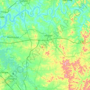
Name: Wilson County topographic map, elevation, terrain.
Location: Wilson County, Tennessee, United States (35.95641 -86.59501 36.35785 -86.01420)
Average elevation: 191 m
Minimum elevation: 134 m
Maximum elevation: 402 m
Thank you for supporting this site ❤️
Make a donation
Make a donation
Other topographic maps
Click on a map to view its topography, its elevation and its terrain.
Thank you for supporting this site ❤️
Make a donation
Make a donation
Thank you for supporting this site ❤️
Make a donation
Make a donation
Shepherd
United States > Tennessee > Hamilton County > Chattanooga > Shepherd
Average elevation: 212 m
Thank you for supporting this site ❤️
Make a donation
Make a donation