
Make a donation
Rajasthan topographic map
Click on the map to display elevation.
Make a donation
Rajasthan
The Aravalli Range runs across the state from the southwest peak Guru Shikhar (Mount Abu), which is 1,722 metres (5,650 ft) in height, to Khetri in the northeast. This range divides the state into 60% in the northwest of the range and 40% in the southeast. The northwest tract is sandy and unproductive with little water but improves gradually from desert land in the far west and northwest to comparatively fertile and habitable land towards the east. The area includes the Thar Desert. The south-eastern area, higher in elevation (100 to 350 m above sea level) and more fertile, has a very diversified topography. In the south lies the hilly tract of Mewar. In the southeast, a large area within the districts of Kota and Bundi forms a tableland. To the northeast of these districts is a rugged region (badlands) following the line of the Chambal River. Farther north the country levels out; the flat plains of the northeastern Bharatpur district are part of an alluvial basin. Merta City lies in the geographical center of Rajasthan.
Make a donation
About this map
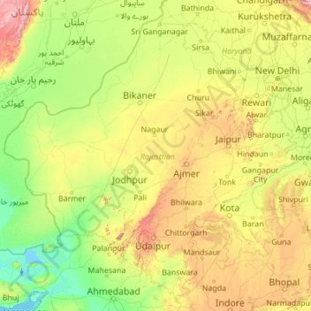
Name: Rajasthan topographic map, elevation, terrain.
Location: Rajasthan, India (23.05866 69.48444 30.19825 78.27201)
Average elevation: 254 m
Minimum elevation: -5 m
Maximum elevation: 2,299 m
Make a donation
Other topographic maps
Click on a map to view its topography, its elevation and its terrain.
Mumbai
Mumbai lies at the mouth of the Ulhas River on the western coast of India, in the coastal region known as the Konkan. It sits on Salsette Island (Sashti Island), which it partially shares with the Thane district. Mumbai is bounded by the Arabian Sea to the west. Many parts of the city lie just above sea level,…
Average elevation: 13 m
Make a donation
Western Ghats
The range starts near south of the Tapti river and runs approximately 1,600 km (990 mi) through the states of Gujarat, Maharashtra, Karnataka, Goa, Kerala and Tamil Nadu ending at Marunthuvazh Malai near the southern tip of India. These hills cover 160,000 km2 (62,000 sq mi) and form the catchment area for…
Average elevation: 2,225 m
Lansdowne
India > Uttarakhand > Lansdowne
Lansdowne is a quaint hill station in the Pauri Garhwal district of Uttarakhand, India. Lodged in the picturesque surroundings of the Himalayan ranges, it lies at an elevation of approximately 1,700 meters (5,577 feet) above sea level. The town is about 45 kilometers (28 miles) from the district headquarters,…
Average elevation: 1,140 m
Dhanbad
India > Jharkhand > Dhanbad-Cum-Kenduadih-Cum-Jagata
Dhanbad has an average elevation of 227 m (745 ft). Its geographical length (extending from north to south) is 15 miles (24 km) and the breadth (stretching across east to West) is 10 miles (16 km). It shares its boundaries with West Bengal in the eastern and southern part, Giridih and Dumka in the North and…
Average elevation: 212 m
Make a donation
Maharashtra
Maharashtra is the third largest state by area in India. The Western Ghats better known as Sahyadri, are a hilly range running parallel to the coast, at an average elevation of 1,200 metres (4,000 ft). Kalsubai, a peak in the Sahyadris, near Nashik city is the highest elevated point in Maharashtra. To the west…
Average elevation: 478 m
Make a donation
Leh
Leh (/ˈlɛ/) (Ladakhi: གླེ) is the joint capital and largest city of Ladakh, a union territory of India. Leh, located in the Leh district, was also the historical capital of the Kingdom of Ladakh, the seat of which was in the Leh Palace, the former residence of the royal family of Ladakh, built in the…
Average elevation: 4,294 m
Shimla
Shimla is on the south-western ranges of the Himalayas at 31°37′N 77°06′E / 31.61°N 77.10°E / 31.61; 77.10. It has an average altitude of 2,206 metres (7,238 ft) above mean sea level and extends along a ridge with seven spurs. The city stretches nearly 9.2 kilometres (5.7 mi) from east to west.
Average elevation: 1,557 m
Guwahati
Professor Abani Kumar Bhagawati of Gauhati University stated that since before there were sufficient wetlands to absorb rainwater and channels to carry excess water to the Brahmaputra, the city did not experience floods. However, human interference has disrupted the natural topography, leading to the current…
Average elevation: 113 m
Make a donation
Vadodara
India > Gujarat > Vadodara Rural Taluka
Vadodara is located at 22°18′N 73°11′E / 22.30°N 73.19°E / 22.30; 73.19 in western India at an elevation of 39 metres (128 ft). It is the tenth-largest city in India with an area of 400 square kilometres (150 sq mi) and a population of 3.5 million, according to the 2010–11 census. The city…
Average elevation: 36 m
Navi Mumbai
India > Maharashtra > Thane > Navi Mumbai
Navi Mumbai (Marathi pronunciation: , also known by its former name New Bombay), is a planned city off the west coast of the Indian state of Maharashtra in Konkan division. The city is divided into two parts, North Navi Mumbai and South Navi Mumbai, for the individual development of Panvel Mega City, which…
Average elevation: 30 m
Kanchipuram
Kanchipuram is located at 12°50′19″N 79°42′06″E / 12.8387°N 79.7016°E / 12.8387; 79.7016, 72 km (45 mi) south-west of Chennai on the banks of the Vegavathi River, a tributary of the Palar River. The city covers an area of 11.6 km2 (4.5 sq mi) and has an elevation of 83.2 m (273 ft) above…
Average elevation: 82 m
Guwahati
Professor Abani Kumar Bhagawati of Gauhati University stated that since before there were sufficient wetlands to absorb rainwater and channels to carry excess water to the Brahmaputra, the city did not experience floods. However, human interference has disrupted the natural topography, leading to the current…
Average elevation: 113 m
Make a donation
Make a donation
Make a donation
Make a donation
Dhrangadhra
India > Gujarat > Dhrangadhra Taluka
Dhrangadhra is located at 22°59′N 71°28′E / 22.98°N 71.47°E / 22.98; 71.47. It has an average elevation of 64 metres (209 feet).
Average elevation: 52 m
Make a donation
Make a donation
Make a donation
Chandauli
India > Uttar Pradesh > Chandauli
Chandauli is located at 25°16′N 83°16′E / 25.27°N 83.27°E / 25.27; 83.27. It has an average elevation of 70 metres (230 ft). Located about 30 kilometers from Varanasi, it comes under Varanasi division of Uttar Pradesh. Mughalsarai, a major railway junction between northern and eastern India is…
Average elevation: 76 m
Kanker
India > Chhattisgarh > Kanker Tahsil
Kanker is located at 20°16′N 81°29′E / 20.27°N 81.49°E / 20.27; 81.49. It has an average elevation of 388 metres (1272 feet).
Average elevation: 405 m
Make a donation
Chang La
Chang La is a high mountain pass in Ladakh at an elevation of 5,391.3024 m (17,688.000 ft) in the Ladakh Range between Leh and the Shyok River valley. The Chang La, on Leh to Pangong Lake road, lies on the Leh-Karu-Sakti-Zingral-Chang La-Durbuk-Tangtse-Pangong Lake motorable road. Karu, which lies on…
Average elevation: 5,464 m
Make a donation
Warangal
India > Telangana > Warangal mandal
Warangal is located at 18°00′N 79°35′E / 18.0°N 79.58°E / 18.0; 79.58. It has an average elevation of 302 metres (990 feet). It is settled in the eastern part of Deccan Plateau made up of granite rocks and hill formations which left the region barren making the cultivation dependent on…
Average elevation: 268 m
Udhagamandalam
India > Tamil Nadu > Udhagamandalam
Ooty is situated in the Nilgiri Biosphere Reserve. Many of the forested areas and water bodies are off-limits to most visitors in order to protect this fragile ecosystem. Some areas of the Biosphere Reserve have been earmarked for tourism development, and steps are being undertaken to open these areas to…
Average elevation: 2,234 m
Make a donation
Make a donation
Western Ghats
The range starts near south of the Tapti river and runs approximately 1,600 km (990 mi) through the states of Gujarat, Maharashtra, Karnataka, Goa, Kerala and Tamil Nadu ending at Marunthuvazh Malai, Swamithope near the southern tip of India. These hills cover 160,000 km2 (62,000 sq mi) and form the catchment…
Average elevation: 2,225 m
Make a donation
Aluva
Aluva Railway Station (IR Code: AWY) is a grade-A railway station in Kerala, and is the third busiest railway station in Kochi after Ernakulam Junction railway station and Ernakulam Town railway station. All passenger and express trains bound to southern Kerala have a stop at it. People travelling from the…
Average elevation: 11 m
Srinagar
India > Jammu and Kashmir > Srinagar (South)
Under the Köppen climate classification, Srinagar has a four-season humid subtropical climate (Cfa) with hot summers and cool winters. The valley is surrounded by the Himalayas on all sides. Due to influence from Himalayan rain shadow and western disturbances, Srinagar has year-round precipitation; the spring…
Average elevation: 1,805 m
Darbhanga
Darbhanga is located in the northern part of Bihar. It lies between 25.53 degrees - 26.27 degrees N and 85.45 degrees - 86.25 degrees E at an average elevation of 171 feet (52 m). Darbhanga district covers an area of 2,279 sq km. Darbhanga is bounded by Madhubani district in the north, Samastipur district in…
Average elevation: 50 m
Make a donation
Thiruvananthapuram
India > Kerala > Thiruvananthapuram
Thiruvananthapuram is built on seven hills by the seashore and is at 8°30′N 76°54′E / 8.5°N 76.9°E / 8.5; 76.9 on the west coast, near the southern tip of mainland India. The city is on the west coast of India and is bounded by the Laccadive Sea to its west and the Western Ghats to its east.…
Average elevation: 33 m
Lucknow
India > Uttar Pradesh > Lucknow
Lucknow stands at an elevation of approximately 123 metres (404 ft) above sea level. The city had an area of 402 km2 (155 square miles) until December 2019, when 88 villages were added to the municipal limits and the area increased to 631 km2 (244 square miles). Bounded on the east by Barabanki, on the west by…
Average elevation: 120 m
Varanasi
India > Uttar Pradesh > Sadar
Varanasi is located at an elevation of 80.71 metres (264.8 ft) in the centre of the Ganges valley of North India, in the Eastern part of the state of Uttar Pradesh, along the left crescent-shaped bank of the Ganges, averaging between 15 metres (50 ft) and 21 metres (70 ft) above the river. The city is the…
Average elevation: 77 m
Make a donation
Dehradun
India > Uttarakhand > Dehradun
The city of Dehradun mainly lies in Doon Valley and is at a varying height from 410 m (1,350 ft) in Clement Town to above 700 m (2,300 ft) at Malsi which is 15 km (9.3 mi) from the city. However, the average elevation is 450 m (1,480 ft) above sea level. Malsi is the starting point of Lesser Himalayan Range…
Average elevation: 904 m
Make a donation
Make a donation
Make a donation
Make a donation
Make a donation
Make a donation
Make a donation