Shannon topographic map
Interactive map
Click on the map to display elevation.
About this map
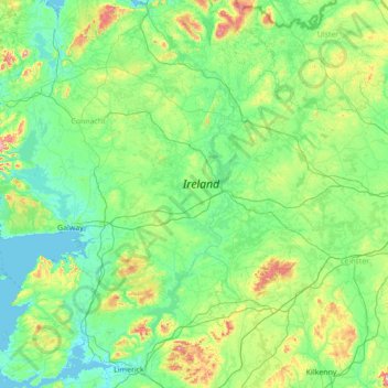
Name: Shannon topographic map, elevation, terrain.
Location: Shannon, Ireland (52.57852 -9.35448 54.23472 -7.87588)
Average elevation: 88 m
Minimum elevation: -2 m
Maximum elevation: 779 m
The lower Shannon between Killaloe and Limerick had a topography quite different from the long upper reaches. Here the river falls by 30 m (98 ft) in only 20 km (12 mi). William Ockenden, also from England, was placed in charge of works on this stretch in 1757 and spent £12,000 over the next four years, without fully completing the task. In 1771 parliament handed over responsibility to the Limerick Navigation Company, with a grant of £6,000 to add to their subscriptions of £10,000. A lateral canal, 8 km (5 mi) long with six locks, was started but the company needed more funds to complete it. In 1791, William Chapman was brought in to advise and discovered a sorry state of affairs – all the locks had been built to different dimensions and he spent the next three years supervising the rebuilding of most of them. The navigation was finally opened in 1799, when over 1,000 long tons (1,000 tonnes) of corn came down to Limerick, as well as slates and turf. But even then, there were no tow paths in the river sections and there were still shoals in the summer months, as well as a lack of harbour facilities at Limerick, and boats were limited to 15–20 long tons (15–20 tonnes) load, often less.
Other topographic maps
Click on a map to view its topography, its elevation and its terrain.
Knockgriffin (Imokilly)
Knockgriffin (Imokilly), Midleton Rural, The Municipal District of East Cork, County Cork, Munster, Ireland
Average elevation: 20 m
Corleggy
Corleggy, Grilly ED, Cavan-Belturbet Municipal District, County Cavan, Ulster, Ireland
Average elevation: 52 m
Glencar
Glencar, Kenmare Municipal District, County Kerry, Munster, Ireland
Average elevation: 114 m
Queenstown No 1
Queenstown No 1, Municipal District of Cobh, County Cork, Munster, Ireland
Average elevation: 22 m
Benmore
Benmore, Westport-Belmullet Municipal District, County Mayo, Connacht, Ireland
Average elevation: 119 m
Kilburne
Kilburne, Waterford City Metropolitan District, County Waterford, Munster, X91 HH58, Ireland
Average elevation: 38 m
Cooraclare
Cooraclare, West Clare Municipal District, County Clare, Munster, Ireland
Average elevation: 34 m
Roundstone
Roundstone, Roundstone ED, Conamara Municipal District, County Galway, Connacht, H91 WP99, Ireland
Average elevation: 34 m
Blackstone
Blackstone, Killag ED, The Borough District of Wexford, County Wexford, Leinster, Ireland
Average elevation: 5 m
Lucan
Lucan, South Dublin, County Dublin, Leinster, K78 Y0F1, Ireland
Average elevation: 59 m
Greenlane
Greenlane, Finnoe, The Municipal District of Nenagh, County Tipperary, Munster, Ireland
Average elevation: 60 m
Marian Place
Marian Place, Portlaoise Rural ED, The Municipal District of Portlaoise, County Laois, Leinster, Ireland
Average elevation: 100 m
Tramore
Tramore, Waterford City Metropolitan District, County Waterford, Munster, Ireland
Average elevation: 41 m
The Borough District of Clonmel
The Borough District of Clonmel, County Tipperary, Munster, Ireland
Average elevation: 118 m
Clonmel
Ireland > County Dublin > Dublin
Clonmel, Ballymun E ED, Dublin, County Dublin, Leinster, Ireland
Average elevation: 57 m
Waterford
Ireland > County Waterford > Waterford
Waterford, County Waterford, Munster, Ireland
Average elevation: 33 m
Clonee
Ireland > County Meath > Clonee
Clonee, The Municipal District of Ratoath, County Meath, Leinster, D15 X036, Ireland
Average elevation: 66 m
Fanore
Ireland > County Clare > Fanore
Fanore, West Clare Municipal District, County Clare, Munster, Ireland
Average elevation: 87 m
Rathmore
Rathmore, Kilscoran ED, The Borough District of Wexford, County Wexford, Leinster, Ireland
Average elevation: 21 m
Rapla
Rapla, Nenagh Rural, The Municipal District of Nenagh, County Tipperary, Munster, Ireland
Average elevation: 78 m
Lambay Island
Lambay Island, Donabate ED, Fingal, County Dublin, Leinster, Ireland
Average elevation: 14 m
Ferns
Ireland > County Wexford > Ferns
Ferns, The Municipal District of Enniscorthy, County Wexford, Leinster, Y21 E8D5, Ireland
Average elevation: 60 m
Ballyguyroe South
Ireland > County Cork > Ballyguyroe South
Ballyguyroe South, Farahy, The Municipal District of Fermoy, County Cork, Munster, Ireland
Average elevation: 95 m
Blarney - Macroom
Ireland > County Cork > Blarney - Macroom
Blarney - Macroom, County Cork, Munster, Ireland
Average elevation: 161 m
Great Skellig
Great Skellig, Kenmare Municipal District, County Kerry, Munster, Ireland
Average elevation: 1 m
Galway City
Ireland > Galway City > Galway City
Galway City, County Galway, Connacht, Ireland
Average elevation: 15 m
Innishannon
Innishannon, The Municipal District of Bandon – Kinsale, County Cork, Munster, T12 P27P, Ireland
Average elevation: 56 m
Ballyhooly
Ballyhooly, The Municipal District of Fermoy, County Cork, Munster, Ireland
Average elevation: 123 m
Portmarnock
Portmarnock, Fingal, County Dublin, Leinster, D13 YV05, Ireland
Average elevation: 7 m
Craughwell
Craughwell, Loughrea Municipal District, County Galway, Connacht, Ireland
Average elevation: 30 m
Shankhill-Rathmichael ED
Shankhill-Rathmichael ED, Dún Laoghaire-Rathdown, Dublin 18, Leinster, Ireland
Average elevation: 95 m