Geolocate

Autonomous City of Buenos Aires topographic map

Interactive map

Click on the map to display elevation.

Autonomous City of Buenos Aires topographic map, elevation, terrain

Autonomous City of Buenos Aires topographic map, elevation, terrain

About this map

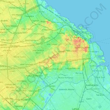
Name: Autonomous City of Buenos Aires topographic map, elevation, terrain.

Location: Autonomous City of Buenos Aires, Argentina (-34.70564 -58.53145 -34.52655 -58.33514)

Average elevation: 14 m

Minimum elevation: -3 m

Maximum elevation: 48 m

Other topographic maps

Click on a map to view its topography, its elevation and its terrain.

San Juan

Argentina > San Juan

San Juan is ranked second among the wine-producing provinces of Argentina. It has a cultivated area of 116,700 acres at altitudes of between 1,970 (601m) and 4,590 feet (1399m) above sea level. This region specializes in Syrah, Malbec, Cabernet Sauvignon, Bonarda, Chardonnay and Torrontés. Because of this…

Average elevation: 694 m

Pedanía La Amarga

Argentina > Córdoba

Average elevation: 151 m

Almanza

Argentina > Río Negro Province > Cinco Saltos

Average elevation: 288 m

San Juan

Argentina

In 2007, the same company installed the world's highest-situated wind turbine at the Veladero mine in San Juan Province at nearly 4,200m elevation.

Average elevation: 1,848 m

Cordillera Blanca

Argentina > Neuquén Province

Average elevation: 1,926 m

Malabrigo

Argentina > Santa Fe

Average elevation: 58 m

Santa Cruz Province

Argentina

From the centre to the Atlantic coast in the east, the landscape is dominated by plateaus. These plateaus are made up of basalt rock occur in stepped sequences. The plateaus are of different ages with the older –of Neogene and Paleogene age– being located at higher elevations than Pleistocene and Holocene…

Average elevation: 350 m

San Antonio de Areco

Argentina > Buenos Aires

Average elevation: 31 m

5M

Argentina > Neuquén Province

Average elevation: 384 m

Libertad

Argentina > Buenos Aires

Average elevation: 27 m

Chubut Province

Argentina

Chubut stretches from the Atlantic to the Andes with 3 distinct environmental regions: The Andes, the central plains and the coastal regions. The Andes in the westernmost parts of the province mostly extend along the Chilean border. The Andes are not that high in Chubut, with most peaks averaging around 1,500…

Average elevation: 556 m

Villa Cristina

Argentina > Chaco > Makallé

Average elevation: 63 m

Mariano Acosta

Argentina > Buenos Aires

Average elevation: 25 m

El Palomar

Argentina > Buenos Aires

Average elevation: 24 m

Nueva Italia

Argentina > Córdoba > Pedanía Capital > Cordoba

Average elevation: 415 m

Universidad

Argentina > Buenos Aires

Average elevation: 30 m

Padre Mugica

Argentina > San Luis > San Luis

Average elevation: 741 m

Luján

Argentina > Buenos Aires

Average elevation: 30 m

San Luis

Argentina > San Luis

Average elevation: 734 m

Mesa

Argentina > Santa Cruz Province

Average elevation: 475 m

Santa Fe

Argentina > Santa Fe

Average elevation: 136 m

Pellegrini Lake

Argentina > Río Negro Province

After the first years of operation of the dam Dique Ing. Ballester, in 1936, the lake that was formed already registered a water level of 267,60 m. Up to this date, that level has small variations around the 272 m elevation.

Average elevation: 287 m

Río Cuarto

Argentina > Córdoba > Río Cuarto

Average elevation: 443 m

Haedo

Argentina > Buenos Aires > Haedo

Average elevation: 28 m

Pergamino

Argentina > Buenos Aires > Pergamino

Average elevation: 72 m

Pilar

Argentina > Buenos Aires

Average elevation: 19 m

Rosario

Argentina > Santa Fe

The airport serves the Greater Rosario area and is the main hub for Sol Líneas Aéreas and is also served by Aerolíneas Argentinas, Copa and Gol Transportes Aéreos. There are domestic flights within Argentina from Rosario to Buenos Aires, Córdoba, Mar del Plata (via Buenos Aires), Mendoza (vía Córdoba),…

Average elevation: 20 m

Neuquén Province

Argentina

Mean temperatures are relatively cold for its latitude due to the high altitude. The warmest region is the eastern parts of the province where mean annual temperatures range from 13 to 15 °C (55.4 to 59.0 °F). The coldest areas are located in the Andean region where mean annual temperatures are below 5 °C…

Average elevation: 809 m

Tierra del Fuego Province

Argentina

Average elevation: 135 m

Río Negro Province

Argentina

The climate of the province is temperate at low elevations, and very cold in the higher Andean peaks.

Average elevation: 621 m

Olavarría

Argentina > Buenos Aires > Olavarría

Average elevation: 167 m

Puerta Tastil

Argentina > Salta > Puerta Tastil

Average elevation: 2,798 m

Susques

Argentina > Jujuy > Susques

Average elevation: 3,669 m

Salta

Argentina > Salta

Average elevation: 1,630 m

Guernica

Argentina > Buenos Aires > Guernica

Average elevation: 28 m

Cordoba

Argentina > Córdoba > Cordoba

Average elevation: 440 m

Funes

Argentina > Santa Fe > Funes

Average elevation: 31 m