
Shimla topographic map
Click on the map to display elevation.
Shimla
Shimla is on the south-western ranges of the Himalayas at 31°37′N 77°06′E / 31.61°N 77.10°E / 31.61; 77.10. It has an average altitude of 2,206 metres (7,238 ft) above mean sea level and extends along a ridge with seven spurs. The city stretches nearly 9.2 kilometres (5.7 mi) from east to west.
About this map
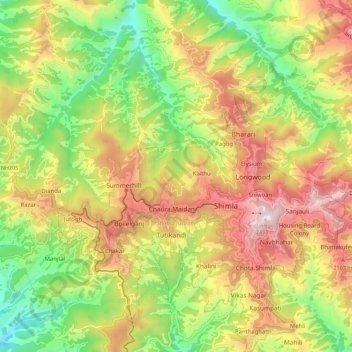
Name: Shimla topographic map, elevation, terrain.
Location: Shimla, Himachal Pradesh, India (31.06418 77.11730 31.16034 77.22992)
Average elevation: 1,826 m
Minimum elevation: 1,276 m
Maximum elevation: 2,439 m
Other topographic maps
Click on a map to view its topography, its elevation and its terrain.