
Thank you for supporting this site ❤️
Make a donation
Make a donation
Mannarkkad topographic map
Click on the map to display elevation.
Thank you for supporting this site ❤️
Make a donation
Make a donation
Mannarkkad
Mannarkkad is located at 10°59′N 76°28′E / 10.98°N 76.47°E / 10.98; 76.47. It has an average elevation of 76 m (249 ft). Mannarkkad is located 36 km north-west of district headquarters Palakkad, along National Highway 966 and 100 km north west of Kozhikode. Mannarkkad is located in the foothills of the Western Ghats.
Thank you for supporting this site ❤️
Make a donation
Make a donation
About this map
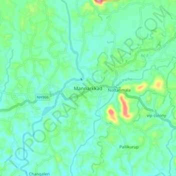
Name: Mannarkkad topographic map, elevation, terrain.
Location: Mannarkkad, Mannarkad, Palakkad, Kerala, 678582, India (10.95290 76.41686 11.03290 76.49686)
Average elevation: 80 m
Minimum elevation: 47 m
Maximum elevation: 201 m
Thank you for supporting this site ❤️
Make a donation
Make a donation
Other topographic maps
Click on a map to view its topography, its elevation and its terrain.